North Cascades Backcountry Hiking and Camping
Permits, Routes, Seasons, and Backup Plans
Last updated: July 2026
Backpacking in the North Cascades is not one permit system, one season, or one kind of trip. Start with where you will sleep, then match the permit, route, road access, season, and backup plan.
This guide is for visitors planning an overnight backcountry trip from the Highway 20 corridor, Cascade River Road, Ross Lake, Baker Lake, or the Methow side near Winthrop and Mazama. The main tradeoff is simple: the famous alpine trips are harder to secure and easier to misjudge, while lower routes and nearby national forest options often make better first trips or backup plans.
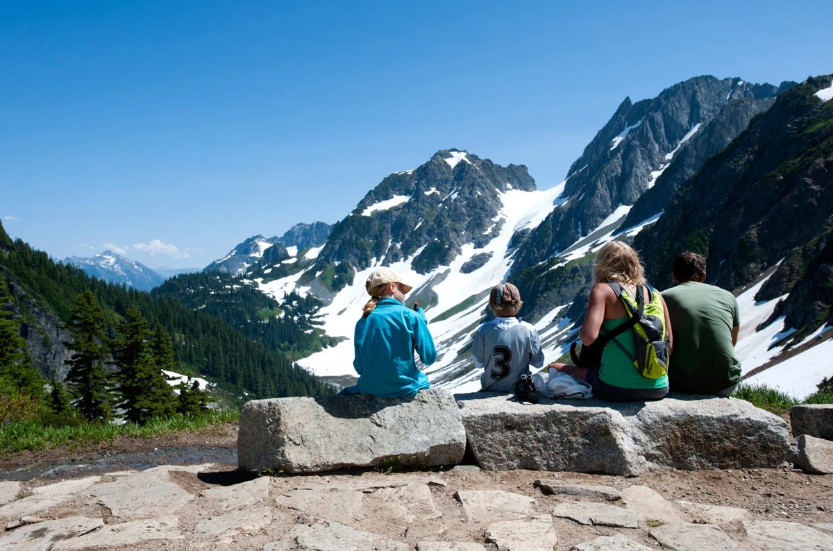
Family resting together at Cascade Pass with Pelton Basin beyond - NPS/Deby Dixon; Public Domain
Get weekly North Cascades updates for seasonal access notes, smoke and closure reminders, new guide updates, and practical Highway 20 planning help.
Quick Decision Guide
The basic rule: choose your overnight camp first. The camp location decides the permit system. The trailhead alone does not.
- If you will sleep inside North Cascades National Park, Ross Lake NRA, or Lake Chelan NRA: plan on a North Cascades backcountry permit. This includes many trail camps, cross-country zones, and Ross Lake boat-in camps.
- If you will sleep on U.S. Forest Service wilderness land outside the park complex: the process is often simpler, but it is not rule-free. Many east-side wilderness trips use free self-issue permits at the trailhead, and some trailheads still require a recreation pass.
- If this is your first North Cascades backpacking trip: look first at lower Thunder Creek, East Bank / Ross Lake, Big Beaver, Baker Lake, or Rainbow Loop near Stehekin. These usually make more sense than starting with Sahale, Copper Ridge, Boston Basin, or Hidden Lake.
- If you want a famous high-alpine trip: treat Sahale, Copper Ridge, Easy Pass, and Harts Pass-area trips as conditional. Snow, road access, permit demand, group skill, and smoke can all change the answer.
- If your permit plan fails: do not cancel the whole trip right away. First decide what you are trying to avoid: the NPS backcountry permit system, a paid trailhead pass, or both. Baker Lake avoids the NPS quota system but still requires a recreation pass. Harts Pass has lower fee friction but a rough seasonal road. Some NPS trailheads avoid parking fees but still require backcountry permits for overnight camping.
Plan A: pick the route you actually want, then verify the permit, pickup method, road access, snow, smoke, fire restrictions, dog rules, and food-storage rules before you commit.
Plan B: choose one lower-demand NPS option and one non-NPS backup before you drive past Concrete or Marblemount. Once you are deep in the corridor, cell service and same-day choices get thinner.
Common mistake: people treat “North Cascades” as one place with one backpacking rule. It is not. A trip east of Diablo, a trip on Cascade River Road, a trip on Baker Lake, and a trip from Mazama can all have different rules.
North Cascades Is Not One Permit System
The phrase “North Cascades backpacking” can mean several different things. You might be sleeping in North Cascades National Park, Ross Lake National Recreation Area, Lake Chelan National Recreation Area, a U.S. Forest Service wilderness, or near a trailhead that only requires a parking pass.
Why this matters: the permit follows the overnight camp, not just the road you drove. A trail can start on national forest land and later enter the park. The rules can change mid-route.
- North Cascades National Park Complex: overnight stays in the backcountry require a backcountry permit year-round. That includes North Cascades National Park, Ross Lake NRA, and Lake Chelan NRA backcountry areas.
- Reservations are not the same as permits: an advance reservation holds space, but the permit still has to be issued and carried correctly.
- Cascade River Road trips: many permits for Eldorado, Boston Basin, and Cascade Pass access must be picked up in person. This makes Marblemount more important than it looks on a map.
- Ross Lake boat-in camps: these are not standard frontcountry camps. They use the park backcountry permit system.
- USFS wilderness areas: many Pasayten and other Okanogan-Wenatchee wilderness trips use free self-issue permits at trailheads. Some trailheads still require a recreation pass.
- Parking passes: a Northwest Forest Pass, digital recreation pass, Interagency Pass, or other parking pass is separate from permission to sleep overnight.
This is where people misjudge the corridor: they see a trail near Highway 20 and assume the rules match a famous national park route. Baker Lake, Cutthroat, Easy Pass, Ross Lake, and Cascade River Road do not all work the same way.
If your trip starts before Marblemount and heads toward Baker Lake, you may be in national forest planning. If your trip starts near Marblemount and turns up Cascade River Road, you are likely dealing with park backcountry permit logistics. If your trip starts east of Diablo or near Rainy Pass, check both the trailhead manager and the overnight camp manager before assuming the rules.
For a broader rule overview, use the North Cascades Permits and Safety Guide.
Best First Backpacking Trips
The best first North Cascades backpacking trip is not always the most famous one. A good first overnight should have a legal camp, a manageable approach, clear rules, and fewer ways for the plan to fail.
Lower Thunder Creek: This is one of the better first-trip targets east of Newhalem near Colonial Creek. It gives you a real North Cascades overnight without starting with a high pass or a fragile alpine camp. It still requires the correct NPS backcountry permit.
East Bank / Ross Lake: This area works well when you want lower-elevation backpacking east of Diablo with a lake-and-forest feel. It can be a good shoulder-season or backup direction, but campsite availability, boat activity, fire closures, and creek or bridge conditions still need checking.
Big Beaver lower valley: This is better for people who can handle more mileage but do not want steep alpine exposure. It is a lower-elevation forest trip, not a quick scenic overlook. Treat bugs, distance, and current closures as part of the plan.
Baker Lake: This is one of the strongest west-side backups if you want to avoid the NPS backcountry quota system. It is lower elevation, national forest managed, and more forgiving than many alpine NPS trips. It is not a no-pass option, though; Baker Lake South and Baker River trailheads require a Recreation Pass, and current Baker Lake road access still needs checking.
Rainbow Loop / Rainbow Bridge: This can work for a Stehekin-based first overnight, but only if the transportation and current Stehekin services make sense. Do not treat Stehekin like a normal drive-up base. There is no road access from the outside.
What I would do: if someone asked for a first North Cascades overnight from the west side, I would look at lower Thunder Creek, East Bank, Big Beaver, or Baker Lake before chasing Sahale. If they were already staying in Winthrop or Mazama, I would compare Cutthroat-area or other east-side options instead of sending them back across the pass to Marblemount.
Icon Trips Need More Planning
Sahale, Cascade Pass, Copper Ridge, Easy Pass, Hidden Lake, Boston Basin, and Harts Pass can be excellent trips. They are also easier to misplan.
Cascade Pass and Sahale: This is the bucket-list route from Cascade River Road near Marblemount. It is also permit-sensitive, road-sensitive, snow-sensitive, and not the best default for a first backpacking trip. The day hike to Cascade Pass is not the same decision as camping at Sahale Glacier Camp. We have an extensive guide that talks about this hike.
Boston Basin: This is not a casual Sahale backup. It overlaps more with climber and cross-country style planning. Use it only if the party has the right experience and the current permit, canister, and access rules line up.
Hidden Lake: This is another place where people confuse a famous hike with a simple overnight. Road access, routefinding, park boundary rules, and camping legality all matter. If the road is closed or washed out, it should not be treated as a normal backup. Road access is discussed here.
Copper Ridge: This is a stronger fit for experienced backpackers who can handle distance, steep snow timing, fragile vegetation, fire history, water gaps, and permit competition. It should not be framed as an easy alternative to Sahale.
Easy Pass and Fisher Creek: The trailhead is east of Diablo on Highway 20, but overnight plans can enter park backcountry. Early-season snow can be a real issue. Do not assume “Highway 20 is open” means this route is ready.
Harts Pass and the PCT: This is usually a Methow-side plan from Mazama or Winthrop, not a quick west-side fallback from Marblemount. The road is narrow and seasonal, and the terrain is exposed. It can be a good east-side alternative when road, smoke, and snow conditions fit.
Common mistake: if Sahale is unavailable, people sometimes jump to Boston Basin or Hidden Lake because they sound nearby and impressive. Nearby does not mean easier. For many groups, Thornton Lakes, lower Thunder Creek, East Bank, or Baker Lake are more realistic backups.
For route-specific planning on the most famous Cascade River Road hike, use the Cascade Pass and Sahale Arm Guide.
When to Go
North Cascades backpacking season depends on elevation, road access, snow, fire, and smoke. Do not use one “best month” for the whole region.
- April and May: think low routes only unless you have winter travel skills. Baker Lake, some Baker River access, and very low valley routes are more realistic than alpine passes.
- June: this is the false-summer month. Highway 20 may be open, but high camps, steep traverses, and north-facing passes can still hold snow.
- July: this is the transition month. Some alpine trips start coming into shape, but early July can still require snow judgment.
- August: this is often the broadest access window, but smoke, wildfire closures, heat on the east side, and permit demand become major planning factors.
- September: this can be excellent for experienced hikers. Watch for smoke, early snow, shorter days, and changing office or service seasons.
- October: choose carefully. Lower routes and some east-side shoulder-season trips may work, but high camps can turn quickly.
- November through March: treat this as winter or specialized shoulder-season travel. Standard backpacking assumptions do not apply.
Local planning note: before you pass Marblemount for a west-side NPS trip, check whether your route is a valley trip or a high-country trip. Those can be in completely different seasons on the same weekend.
For current access, use the North Cascades Seasonal Access Guide before you choose a route. For same-week problems, use North Cascades Current Conditions.
If Your Plan Fails
A failed permit is not always a failed trip. First figure out which part failed: the permit, the road, the season, the smoke, the group fit, the parking pass, or the pickup logistics.
First sort the failure: “No permit,” “no parking pass,” and “no advance reservation” are three different problems. A route can avoid the NPS quota system and still need a Northwest Forest Pass, Recreation Pass, or day-use fee. Another route can avoid a trailhead parking fee but still require an NPS backcountry permit for overnight camping.
If Sahale or Cascade Pass is sold out: check lower-demand NPS options first. Lower Thunder Creek, East Bank, Big Beaver, and Thornton Lakes may fit different groups. These are not no-permit trips if you sleep in the park complex, but they may keep the trip in the same broad Highway 20 corridor without jumping to a harder alpine backup.
If you want to avoid a parking pass: trailheads that begin on National Park Service land generally do not have a separate trailhead or parking fee. That does not remove the backcountry permit requirement. If you are sleeping in the park complex, you still need the correct backcountry permit.
If you want to avoid the NPS quota system: look outside the park complex. Baker Lake is the strongest west-side backup because it is lower elevation, national forest managed, and does not use the NPS backcountry quota system. It is not a no-pass option; Baker Lake South and Baker River trailheads require a Recreation Pass.
If you want the lowest fee friction on the east side: Harts Pass is one of the cleaner options because the trailhead currently lists no site fee. The tradeoff is access. The road is typically a July-to-September route, is rugged and narrow, and is better from Mazama or Winthrop than from Marblemount.
If you are considering Cutthroat / PCT-style trips: treat them as route backups, not no-pass backups. Cutthroat Trailhead requires a day-use fee or accepted recreation pass, and parking is very limited. It can still be a good east-side choice from Winthrop or Mazama when the season and parking plan fit.
If SR-20 is closed or not fully open: do not build a trip around Rainy Pass, Washington Pass, Easy Pass, Cutthroat, Bridge Creek, or Harts Pass until access is verified. West-side options such as Baker Lake may be more realistic, as long as Baker Lake-area road access is also open.
If Cascade River Road is blocked: do not force a Cascade Pass plan. Shift to Thunder Creek, East Bank, Baker Lake, or a frontcountry base with day hikes, depending on current conditions.
If Baker Lake Road is restricted: check the current Forest Service alert before using Baker River or north-end Baker Lake access. A road issue there can remove one of the best west-side backups.
If smoke is bad east of the crest: do not assume the Methow backup is better. Compare west-side routes, lake routes, and lower forest options before driving toward Winthrop or Mazama.
If your group includes a dog: many national park backcountry routes will not work. Ross Lake NRA, Lake Chelan NRA, and USFS routes may offer more options, but leash and site-specific rules still apply.
What I would do: choose one NPS backup, one no-NPS-quota backup, and one simple frontcountry backup before leaving home. If you wait until you are in Marblemount with no permit, no service, and tired passengers, the decision gets worse.
Where to Stay Beforehand
Your overnight base should match your trailhead and permit pickup plan. Marblemount, Concrete, Newhalem, Winthrop, Mazama, Twisp, and Stehekin are not interchangeable.
Marblemount: best for the Wilderness Information Center, Cascade River Road, Cascade Pass, Sahale, Boston Basin, Thunder Creek, East Bank, and Ross Lake west-side starts. It beats Concrete for dawn-start convenience, but Concrete usually has more service depth before you enter the sparse corridor.
Concrete: better if you want more services before driving east toward Marblemount and Newhalem. It is less convenient for early permit pickup, but it can be a smarter supply stop.
Newhalem: useful for proximity to Thunder Creek, Diablo, and East Bank access, but do not treat it as a full resupply town. Get food, fuel, and last-minute supplies before you rely on in-park services.
Winthrop and Mazama: best for east-side starts such as Cutthroat, Easy Pass, Bridge Creek, Washington Pass, and Harts Pass. They beat Marblemount for Methow-side trailheads, but they are the wrong side of the mountains if you need in-person Marblemount permit handling.
Twisp: useful for Twisp River and Lake Chelan-Sawtooth alternatives. It is less convenient for Harts Pass than Mazama, but better for some southern Methow entries.
Stehekin: only use this as a base if your boat, shuttle, lodging, and current services are already lined up. Stehekin is not a last-minute drive-up backup.
For west-side lodging choices, start with Where to Stay in Marblemount. For a broader base comparison, use Where to Stay in the North Cascades.
Rules That Change the Trip
Backcountry rules are not just fine print here. They can decide whether a route works at all.
Food storage: some camps and zones require approved hard-sided bear canisters during the main season. If you need to borrow one, that can affect permit pickup and your timing in Marblemount.
Dogs: leashed pets are allowed in Ross Lake NRA and Lake Chelan NRA and on many surrounding national forest lands. Pets are generally not allowed inside North Cascades National Park except on the Pacific Crest Trail and along roads. This is one of the fastest ways to eliminate the wrong routes.
Fires: alpine, fragile, cross-country, and high-use areas often have strict fire limits, and seasonal bans can expand quickly during fire season. Plan on a stove and verify current restrictions before leaving.
Toilets and waste: do not assume every backcountry camp has a toilet. Cross-country and high alpine travel may require catholes or packing waste out, depending on terrain and rules.
Snow and creek crossings: early-season steep snow can make a route unsafe even when the mileage looks moderate. Creek crossings and bridge status can also turn a normal route into a turnaround.
Cell service: expect poor or no service after the towns and deeper in the park. Download maps, permit details, directions, and backup options before you pass the last reliable service area.
Road access: Cascade River Road, Harts Pass Road, Hidden Lake Road, Thornton Lakes Road, and Baker Lake-area roads can all change the plan. Check the official road source before committing to a route.
Sources to Check
Use these official sources for current rules and time-sensitive planning. Do not rely on blogs, old trip reports, or social media for legal camping rules.
- Backcountry Permits — permit pickup, email issuance, walk-up permits, and year-round permit basics.
- Backcountry Reservations — current reservation season, lottery, walk-up, and timing details.
- Recreation.gov Permit Page — campsite availability, reservation fees, and reservation workflow.
- Operating Hours — Wilderness Information Center and visitor facility hours.
- Trail Conditions — current park trail, bridge, snow, fire, and camp notes.
- Road Conditions — SR-20, Cascade River Road, Thornton Lakes Road, Hidden Lake Road, and Stehekin-area status.
- Food Storage Requirements — bear canister and food-storage rules.
- Pets in North Cascades — dog rules by park, NRA, PCT, and surrounding lands.
- Fees and Passes — NPS fees, USFS trailhead passes, and Discover Pass distinction.
- Pasayten Wilderness — self-issue wilderness permit basics and recreation pass notes.
- Baker Lake Trail — national forest trail information for a lower-elevation backup.
- Baker Lake Road Alert — current Baker Lake Road and Baker River access restriction.
- SR-20 Pass Status — current North Cascades Highway access.
- AirNow — current smoke and air-quality checks.
- Harts Pass Trailhead — current fee, road-season, vehicle-suitability, and trailhead details.
- Cutthroat Trailhead — current fee/pass, parking, camping restriction, and trailhead details.
Related Guides
Backcountry permits, road access, trail conditions, fire restrictions, food-storage rules, and smoke conditions can change quickly. Verify current rules with the National Park Service, Recreation.gov, U.S. Forest Service, WSDOT, and current fire or smoke sources before leaving.