
North Cascades Two-Day Itinerary
Last updated: May 2026
Two days is the most practical way to see the North Cascades without turning the trip into one long drive. The best version is not just “add more stops.” It is choosing the right overnight base, splitting the west-side and high-pass portions of the route, and keeping a backup plan ready if weather, smoke, snow, or road access changes.
This guide is built as an evergreen route framework. Use it to decide how to shape your two days, then check current conditions and seasonal access before committing to the high-country or east-side portions of the plan.
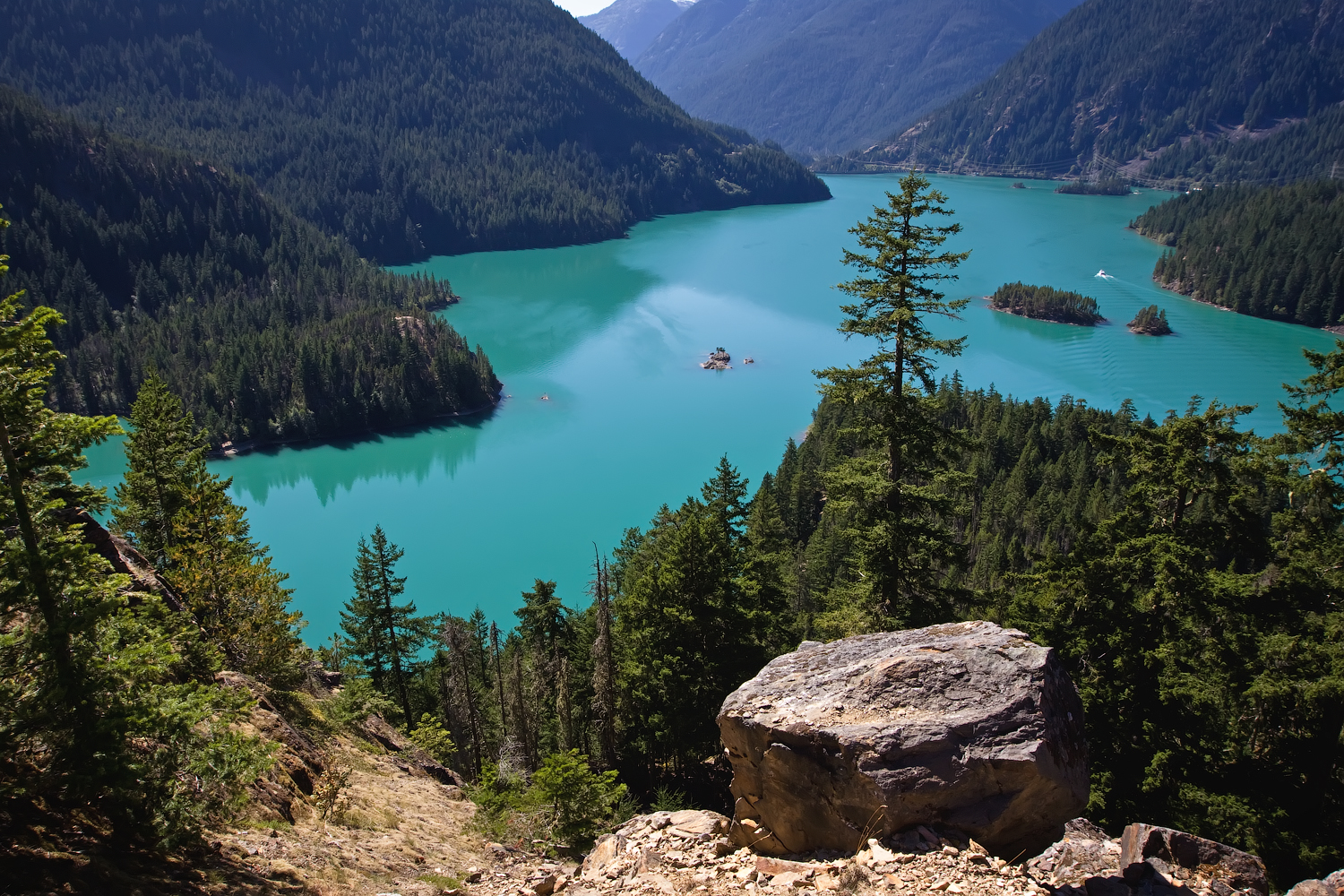
Diablo Lake overlook view along Highway 20 - Steven Pavlov | CC BY-SA 4.0
Start here before using this itinerary
Access changes the whole trip. A normal two-day plan can include Diablo Lake, Rainy Pass, and Washington Pass. A partial-closure or poor-weather plan should stay farther west and use Newhalem, Diablo, Gorge Creek Falls, nearby services, and backup stops instead.
Before your trip, check Current Conditions, Seasonal Access, and the This Weekend plan if you are traveling soon.
Quick Decision Guide
- Best normal two-day plan: Day 1 focuses on the west corridor from Newhalem to Diablo Lake. Day 2 goes higher toward Rainy Pass and Washington Pass only when SR 20 is open and visibility is worth the drive.
- Best overnight base for most first-time visitors: Use the where to stay near North Cascades guide to choose between Marblemount for earliest park access, Rockport for a quieter middle option, or Concrete for more services and flexibility.
- Best family-friendly version: Keep both days simple with family-friendly North Cascades stops like Newhalem, Gorge Creek Falls, Diablo Lake Overlook, short walks, and Rainy Lake only if the high-elevation road access is open and weather is clear.
- Best hiking version: Use Day 1 for viewpoints and Day 2 for one real hike. Do not try to combine a serious hike, Cascade River Road, Rainy Pass, and Washington Pass in the same day.
- Best bad-weather or closure version: Use the backup plans guide to stay west of the closure or low-visibility zone, repeat Diablo at a better time of day, add Newhalem-area stops, use nearby services, and save the high-pass stops for another trip.
- If you only have one long day: Use the one-day North Cascades itinerary instead of forcing this two-day plan into a rushed schedule.
How to Use This Two-Day Route
The main idea: Split the trip by decision type. Day 1 should be your lower-risk west-side day with Newhalem, Gorge Creek Falls, Diablo Lake, and nearby overlooks. Day 2 should be your flexible day: high-pass scenery if SR 20 is open, Cascade River Road if you are planning a hike, or a west-side backup plan if access or weather is poor.
Do not treat the North Cascades Highway like a guaranteed through-road. The high-elevation section closes seasonally and can be affected by snow, slides, fire, smoke, and repair work. This page gives you the structure; Current Conditions tells you which version is usable right now.
Plan west to east unless your lodging says otherwise. Most visitors coming from Seattle, Everett, Bellingham, or Skagit Valley will enter through Concrete, Rockport, and Marblemount before reaching the national park corridor. That makes food, fuel, and overnight base selection part of the itinerary, not a separate detail.
Day 1: West-Side Corridor Plan
Goal for Day 1: See the core west-side stops without burning the whole trip on a single viewpoint or trailhead. This day should feel controlled, not rushed.
Before Marblemount: Handle fuel, food, water, and bathroom stops before you drive deeper into the corridor. Concrete gives you more services. Rockport is quieter but limited. Marblemount is the last practical base before the park corridor tightens.
- Newhalem: Use this as the first real reset point. It works well for visitor-center context, easy walking, bathrooms when available, and adjusting the day if you arrived earlier or later than planned.
- Gorge Creek Falls: A short, high-value stop east of Newhalem. This is one of the easiest wins on a two-day trip because it does not require a major time commitment.
- Diablo Lake Overlook: The main west-side viewpoint for many visitors. If parking is full or the light is poor, do not let it trap the whole day. Continue to another stop and consider returning later.
- Happy Creek Forest Walk: A useful pressure-release stop when overlooks are crowded or the weather favors forest walks over open views.
- Ross Lake overlooks and pullouts: Good short stops when you want to keep moving and avoid overcommitting late in the day.
End Day 1 near your Day 2 goal. If Day 2 is a high-pass scenic day, stay west but close enough for an early start. If Day 2 is Cascade River Road, Marblemount is the most efficient base. If your plan depends on services, Concrete may be easier even though it adds drive time.
Pick Your Overnight Base Before Day 2
Why this matters: Your overnight base controls your Day 2 start time. A “good deal” farther away can cost you the early window you need for parking, weather, or pass-level visibility.
Marblemount: Best if your priority is early access to the park corridor or Cascade River Road. This is the most efficient base for hikers and visitors who want to minimize morning drive time. The tradeoff is fewer services and fewer backup options.
Rockport: Best if you want a quieter middle position. It is not as close as Marblemount and not as service-heavy as Concrete, but it can work well for visitors who want a calmer overnight without getting too far from the corridor.
Concrete: Best if you want more services, food, gas, and fallback flexibility. It adds driving time each day, but it is often easier for families, late arrivals, and visitors who want fewer logistics surprises.
East-side overnight: Only consider this when SR 20 is fully open through the high-elevation corridor and your trip is designed as a through-drive or Methow Valley continuation. Do not book an east-side base unless the road access plan makes sense for your actual travel dates.
Day 2 Option A: Rainy Pass and Washington Pass When SR 20 Is Open
Use this version when: SR 20 is open through the corridor, high-elevation visibility is good, and you want the classic second day with bigger mountain views.
Start early: Leave your overnight base with enough time to reach the high country before midday crowds, haze, or weather changes. If you are staying in Concrete, build in more drive time. If you are staying in Marblemount, you have a better margin.
- Rainy Pass area: Use this as the main Day 2 decision point. It can support an easier walk, a longer hike, or a simple scenic stop depending on the season, parking, and weather.
- Rainy Lake: A strong fit for families, mixed-ability groups, or visitors who want a real destination without committing to a harder hike.
- Washington Pass Overlook: The best final high-country viewpoint when access and visibility cooperate. This stop is often more rewarding when the sky is clear enough to justify the drive.
Cut first if the day slips: Skip extra pullouts, reduce duplicate overlook time, and avoid adding a second hike. Do not sacrifice your safe return window just to “complete” the itinerary.
Turn back early if needed: Pass-level weather can change faster than conditions around Marblemount or Newhalem. If visibility collapses, smoke thickens, or road conditions feel questionable, use your west-side backup plan instead.
Day 2 Option B: Cascade River Road Hike Day
Use this version when: Your main goal is a bigger hike from the Marblemount side, not a full SR 20 high-pass sightseeing day.
Do not combine this with Washington Pass. Cascade River Road is a major time commitment. It branches off near Marblemount, runs deep into the mountains, and can be slow depending on road condition, traffic, and trailhead access. Treat it as the main event of Day 2.
Best overnight base: Marblemount is the most efficient choice. Rockport can work. Concrete is possible but adds drive time before and after the hike.
Access caution: Cascade River Road often has a different access pattern than SR 20. It may open, close, or remain limited on a different timeline. Always check road and trail status before making it your Day 2 anchor.
Tradeoff: You gain a more serious mountain day, but you give up Rainy Pass, Washington Pass, and most of the east-side corridor for this trip.
Day 2 Option C: Closure, Rain, Smoke, or Low-Visibility Backup
Use this version when: SR 20 is not open through the corridor, the pass-level forecast looks poor, wildfire smoke reduces views, or your group needs a lower-risk second day.
The mistake to avoid: Do not drive deeper just because the original itinerary said “Day 2 = Washington Pass.” If access or visibility is bad, you are spending time and fuel for a weak payoff.
- Repeat Diablo Lake at a better time of day: Morning, afternoon, and changing cloud cover can make the same overlook feel different.
- Add Newhalem-area walks: Good for families, limited mobility groups, and days when open viewpoints are not worth chasing.
- Use Gorge Creek Falls and nearby pullouts: These stops still work when the high country is not cooperating.
- Stay closer to services: Concrete, Rockport, and Marblemount make more sense when you need food, fuel, flexibility, or an easier exit.
- Consider a non-hiking add-on: If the season and conditions fit, rafting, town stops, or a shorter scenic drive may be better than forcing a trail day.
Food, Fuel, Parking, and Timing Strategy
Fuel: Do not push your gas stop too far east. Services become limited quickly after Concrete, Rockport, and Marblemount. Handle fuel before the scenic part of the day begins.
Food: Pack enough to avoid losing itinerary time to backtracking. A two-day trip gives you more flexibility, but only if you do not spend the best daylight trying to solve basic logistics.
Parking: Diablo Lake Overlook, high-elevation trailheads, and popular stops can fill or turn over unpredictably. If a stop is jammed, keep moving and return later rather than letting one parking lot control the entire day.
Timing: Start earlier than you think you need to, especially on weekends, sunny summer days, larch-season weekends, and holiday periods. The second day should have a cut list before you leave your lodging.
Best cut list: Cut duplicate pullouts first, then optional short walks, then extra trail mileage. Do not cut food, fuel, road checks, or safe return time.
Common Two-Day Itinerary Mistakes
- Planning Day 2 around a road that may not be open: Always check access before building the high-pass version of the trip.
- Booking lodging before choosing the route: A base that looks convenient on a map may add too much drive time for your actual plan.
- Combining Cascade River Road and Washington Pass: Both can be worthwhile, but they do not belong in the same realistic Day 2 for most visitors.
- Arriving at Diablo Lake with no backup stop: Crowds, light, weather, and parking can all reduce the payoff. Have a second nearby stop ready.
- Ignoring services: Food, fuel, and bathrooms are part of the itinerary in this corridor. Handle them before the remote stretch.
- Treating a two-day trip like a completion checklist: The goal is a better-paced trip, not every possible stop. Choose the version that fits current access and your group.
Best Two-Day Itinerary by Trip Style
First-time scenic road trip: Day 1 Newhalem, Gorge Creek Falls, Diablo Lake, and nearby overlooks. Day 2 Rainy Pass and Washington Pass if open and clear. Stay in Marblemount, Rockport, or Concrete depending on service needs.
Family-friendly trip: Keep both days shorter and avoid overcommitting to big hikes. Prioritize Newhalem, Diablo, Gorge Creek Falls, easy walks, and Rainy Lake only when access and weather make it easy.
Hiking-focused trip: Use Day 1 for scenic stops and Day 2 for one main hike. Pick either the Rainy Pass / Washington Pass zone or Cascade River Road. Do not try to build both into the same day.
Services-first trip: Stay closer to Concrete or Rockport, keep the plan flexible, and use the west corridor as the core of the itinerary. This works better for late arrivals, families, uncertain weather, and visitors who do not want the trip to depend on one road segment.
Through-drive trip: Only use this when SR 20 is fully open and you are intentionally continuing toward the Methow Valley or eastern Washington. Otherwise, a west-side base with an out-and-back Day 2 is usually easier to manage.
Related Guides
Disclaimer: Conditions, closures, weather, wildfire smoke, snow, and road access can change quickly in the North Cascades. Use this itinerary as a planning framework and verify current information before travel.
