
Accessible Walks Near Marblemount
Last updated: March 3, 2026
If you want an easy, low-friction stop on SR-20 near Marblemount, start west-side with Rockport State Park or Newhalem boardwalks, then only commit to the high passes (Rainy Pass, Washington Pass) when SR-20 is fully open and the snowline is gone. This guide is built for planning: where to stop first, what fills up, what needs a pass, where restrooms actually are, and what to do when your original plan fails.
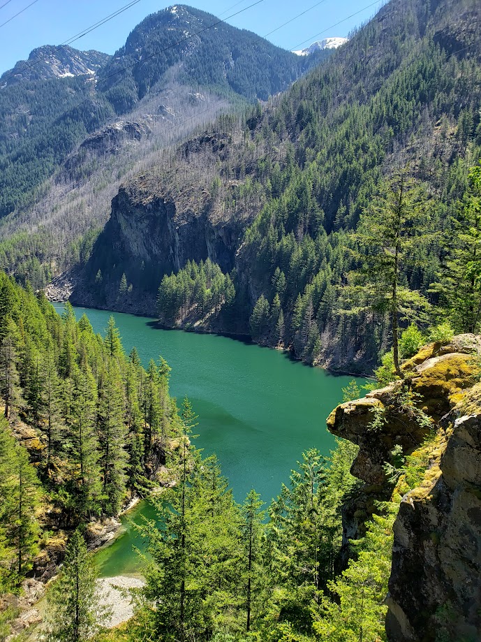
Accessible overlook on SR-20 near Diablo Lake with paved path and viewpoints. Photo: © 2026 CascadesFieldGuide.com. All rights reserved.
Quick Decision Guide
- 2 hours total (round trip from Marblemount): Do Rockport State Park ADA loops (west of Marblemount) or Sterling Munro Boardwalk (Newhalem). Save Diablo/high passes for another day.
- Half-day (4-6 hours) with low walking tolerance: Rockport - Newhalem boardwalks - 1 Diablo viewpoint - back west. Keep it to 2-3 stops to avoid “too much driving, no payoff.”
- Kids + stroller: Prioritize boardwalks and paved overlooks near Newhalem/Diablo. Avoid committing to Rainy Pass unless you already verified the trail is clear and parking is realistic.
- Poor weather (rain, low clouds) or you just want a sure thing: Stay lower-elevation near Newhalem and Rockport. Skip Rainy Pass and Washington Pass.
- Mid-summer weekend and you hate parking stress: Do early morning Diablo or high passes first, then work back toward Newhalem. If you are arriving mid-day during the summer, assume the popular lots will be congested and build a backup stop.
Related Guides
Closest accessible walks
This section is for the days when you want a real stop without driving deep into the corridor.
Pressentin Park (Marblemount)
If you want a “reset walk” before you commit east, Pressentin Park is the easiest one to stack with your Marblemount errands. It is a Skagit County day-use park with a simple perimeter “birding trail” that stays essentially flat, and it does not require a parking pass. (place info) (county info).
- Tip: This is not a “trailhead with facilities” vibe - it is a county park loop on a racked gravel trail. If you need a guaranteed restroom or supplies, handle that at the Shell gas station next door.
- Best for: a low-friction leg stretch before SR-20 dead zones, kids who need to move, and “we have 30 minutes and want something close.”
Marblemount Boat Launch Trail (Marblemount)
If you want the most practical “one last stop” walk right at the edge of the corridor, use the Marblemount Boat Launch Trail. It is a flat riverside path that starts from the boat launch lot just over the Skagit River bridge on Cascade River Road, has a toilet at the trailhead, and does not require a parking pass. Some trail spots can get soft during the rainy season, so wear boots. (trail info)
- Tip: Use this when “restroom certainty” matters. There's always a porta-potty on-site.
- Best for: a flat walk with a real trailhead lot, a quick “stretch and reset” before Newhalem/Diablo, and a low-risk stop when weather is iffy but you still want a worthwhile walk (WTA describes this as a flat trail along the rivers).
Rockport State Park (west of Marblemount)
If the high passes are snowed in, SR-20 is not fully open, or you want a low-risk option close to Marblemount, Rockport State Park is the practical choice. It has ADA-accessible trail options (check official source for current accessibility notes and conditions at the park page).
- Tip: Bring (or buy) the correct parking pass. Rockport State Park is a Washington State Park and typically uses the Discover Pass system.
- Best for: limited mobility, stroller walks, early season, and “we only have 2 hours.”
Before you drive east of Marblemount (passes, restrooms, cell service)
Tip: Treat Marblemount as your last reliable “reset point” before going further east. Fuel up, use a restroom, and download offline maps before you commit east.
- Road status matters: SR-20 is seasonal. If it is not fully open, your accessible options shift west immediately. Check official source before you drive (North Cascades road conditions).
- Cell service is not a plan: Expect dead zones and slow data. Do not assume you can look up “the next restroom” on the fly.
- Pass confusion is common: Some stops are state park (Discover Pass), some are Forest Service trailheads, and the North Cascades National Park complex does not charge an entrance fee (fees and passes). If you do not know which lot you’re using, assume you might need to verify at the official page for that stop.
Newhalem easy wins (boardwalks and short overlooks)
Newhalem is the first area east of Marblemount where you can stack multiple short, accessible stops without major hiking commitment.
Sterling Munro Boardwalk (Newhalem)
This is a straightforward, low-effort option that works for strollers and limited mobility. Use it as your guaranteed stop when energy is unpredictable (place info).
- Tip: If you need “something that will definitely work today,” do this first before you gamble on any higher-elevation stop.
Gorge Creek Falls and nearby viewpoints (Newhalem area)
These stops are popular because they are short and close to SR-20. Accessibility details vary by exact viewpoint and surface conditions, so use the official accessibility page as your final check (Gorge Creek Falls accessibility).
- Tip: Use Gorge Creek as your “weather fallback” stop - if it starts raining harder, you still get a worthwhile short walk without committing to the pass drive.
Diablo area viewpoints (short stops with big payoff)
East of Newhalem, the Diablo area is where short stops feel “worth it” without major walking. These are also the stops that can turn into a parking mess if you arrive at the wrong time.
Diablo Lake Overlook
This is one of the most planning-efficient accessible stops on the corridor. Use the official accessibility page for current details on parking, surfaces, and restroom availability (Diablo Lake Overlook accessibility).
- Tip: If your day only has room for one “iconic” stop east of Newhalem, this is usually the best value per minute.
- Tip: Build a backup viewpoint nearby in case the lot is full. Do not let one crowded lot break your whole day.
Diablo Vista Point (often used as a quick-access viewpoint)
Some Diablo-area viewpoints can have quick turnover, but congestion spikes mid-day in peak season. If your mobility is limited and you cannot “circle and wait,” aim to arrive earlier or choose a lower-stress stop first.
High passes (Rainy Pass and Washington Pass)
These are only “accessible-easy” during the right season. In early season, snow and ice can make a paved path effectively unusable.
Rainy Lake Trail (Rainy Pass)
This is a paved trail that is often the top accessible-walk recommendation in the North Cascades. The catch is timing: snow coverage can linger into early summer. Check the official page before you commit to the drive (Rainy Lake Trail accessibility and conditions guidance).
- Tip: If it is May or early June, assume Rainy Pass might still be snow-covered until you verify otherwise on an official source or very recent, reliable trip reports.
- Tip: Parking pressure is real at Rainy Pass in peak season. If this is your must-do, build the day around arriving early.
- Tip: Rainy Lake trailhead parking is typically tied to Forest Service pass requirements (the official page above includes the pass note - verify there before you go).
Washington Pass Overlook
This is a short viewpoint walk with accessibility notes that matter in practice (surface, grade, and width can change how “easy” it feels). Check the official accessibility page before treating it as a sure thing (Washington Pass Overlook accessibility).
- Tip: “Paved” does not always mean “easy without assistance.” If you have very limited mobility, treat this as “possible with help” unless the official page clearly matches your needs.
Plan A / Plan B for route and conditions
Plan A (SR-20 fully open, passes clear)
Time budget: 4-6 hours from Marblemount
- Start in Marblemount: fuel + restroom + offline maps.
- Newhalem: Sterling Munro Boardwalk (guaranteed low-friction win).
- Diablo: one primary viewpoint (Diablo Lake Overlook) plus a backup viewpoint if parking is tight.
- If conditions are confirmed good and you still have energy: choose Rainy Pass (Rainy Lake) or Washington Pass Overlook - not both unless you want a drive-heavy day.
Plan B (SR-20 not fully open, smoke, heavy rain, early-season snow)
Time budget: 2-4 hours from Marblemount
- Rockport State Park ADA loops (west of Marblemount) as the anchor stop.
- If weather allows and you want one corridor stop: Newhalem boardwalks and the shortest nearby viewpoint.
- Skip the high passes entirely unless you verify conditions.
Trigger Plan B immediately if: SR-20 status is uncertain (check official source), air quality is poor (check official source: https://www.airnow.gov), or you are early season and high-elevation surfaces are likely snow/ice (check official source for Rainy Lake and Washington Pass pages linked above).
FAQ
- Do you pay an entrance fee for North Cascades National Park? The North Cascades National Park complex does not charge an entrance fee, but some parking areas require other passes depending on who manages the lot. Verify on the specific official page for your stop (fees and passes).
- Is Rainy Lake accessible year-round? No. Even after the pass opens late spring, snow and ice on the paved trail can make it effectively inaccessible until later in the season. Check official source before planning your day around it (Rainy Lake accessibility).
- What is the easiest “sure thing” stop east of Marblemount? Sterling Munro Boardwalk near Newhalem is the most reliable low-effort option, especially when weather or energy is uncertain (place info).
- Where should I base if I want minimal driving? Marblemount is the closest base to the west-side corridor stops. Start with Where to stay in Marblemount.
Sources
- North Cascades National Park - Road Conditions (SR-20 status
- North Cascades National Park - Fees & Passes
- North Cascades National Park - Sterling Munro Boardwalk
- North Cascades National Park - Accessibility at Gorge Creek Falls
- North Cascades National Park - Accessibility at Diablo Lake Overlook
- North Cascades National Park - Accessibility at Rainy Lake Trail (includes pass note)
- North Cascades National Park - Accessibility at Washington Pass Overlook
- Washington State Parks - Rockport State Park (passes, current info)
- AirNow - air quality and smoke
Disclaimer
This is a planning guide, not a real-time conditions report. Trail surfaces, snow, smoke, and facility availability can change quickly on the SR-20 corridor. For time-sensitive decisions (road status, closures, accessibility conditions, and pass requirements), check the official sources linked above before you drive.
