
Washington Pass Overlook: Short Walk, Best Views, Wind Tips
Last updated: March 2026
Attribution: Forest Service Pacific Northwest Region via Wikimedia Commons (Public Domain).
Washington Pass Overlook is the highest-payoff “short walk” stop on the east side of the North Cascades Highway. If SR 20 is open through the pass, you can get iconic Liberty Bell and Early Winters Spires views with an easy, paved walk; if SR 20 is closed for the winter, you cannot reach it from the west side, so do not gamble your day on it. (check WSDOT SR 20 status)
Click to Get Road and Weather Updates
Quick decision guide
If SR 20 is open through the pass
Washington Pass Overlook is worth treating as one of the best short-walk scenic stops on the east side of the highway.
If SR 20 is not open through Washington Pass
Do not build your day around this stop from the west side. You will not be able to reach it from Marblemount, Newhalem, or Diablo when the pass is closed. (check WSDOT SR 20 status)
If you want a fast, high-payoff viewpoint
This is one of the best “views per minute walked” stops on Highway 20 because the walk is short, paved, and easy.
If weather or wind is rough
Treat it as a short, decisive stop rather than a long linger. Get the view, take photos, and move on.
Related Guides
Getting there and access checks
- Where it fits in the corridor flow: Washington Pass Overlook is far east of Newhalem and the Diablo Lake corridor. If you are coming from the west side (Marblemount, Newhalem), this stop is only realistic if SR 20 is open through Rainy Pass and Washington Pass (check official source) (WSDOT SR 20 status).
- Seasonal closure reality: NPS explains snow and avalanche hazards usually close SR 20 in late fall/early winter and that reopening is weather and snow dependent; it also lists Washington Pass as the high point at 5,477 feet (expect winter conditions earlier and longer) (NPS road conditions).
- Tip: Check status again the morning you drive. SR 20 conditions can change quickly due to weather and avalanche control (check official source) (WSDOT SR 20 status).
Overlook Parking and the short walk
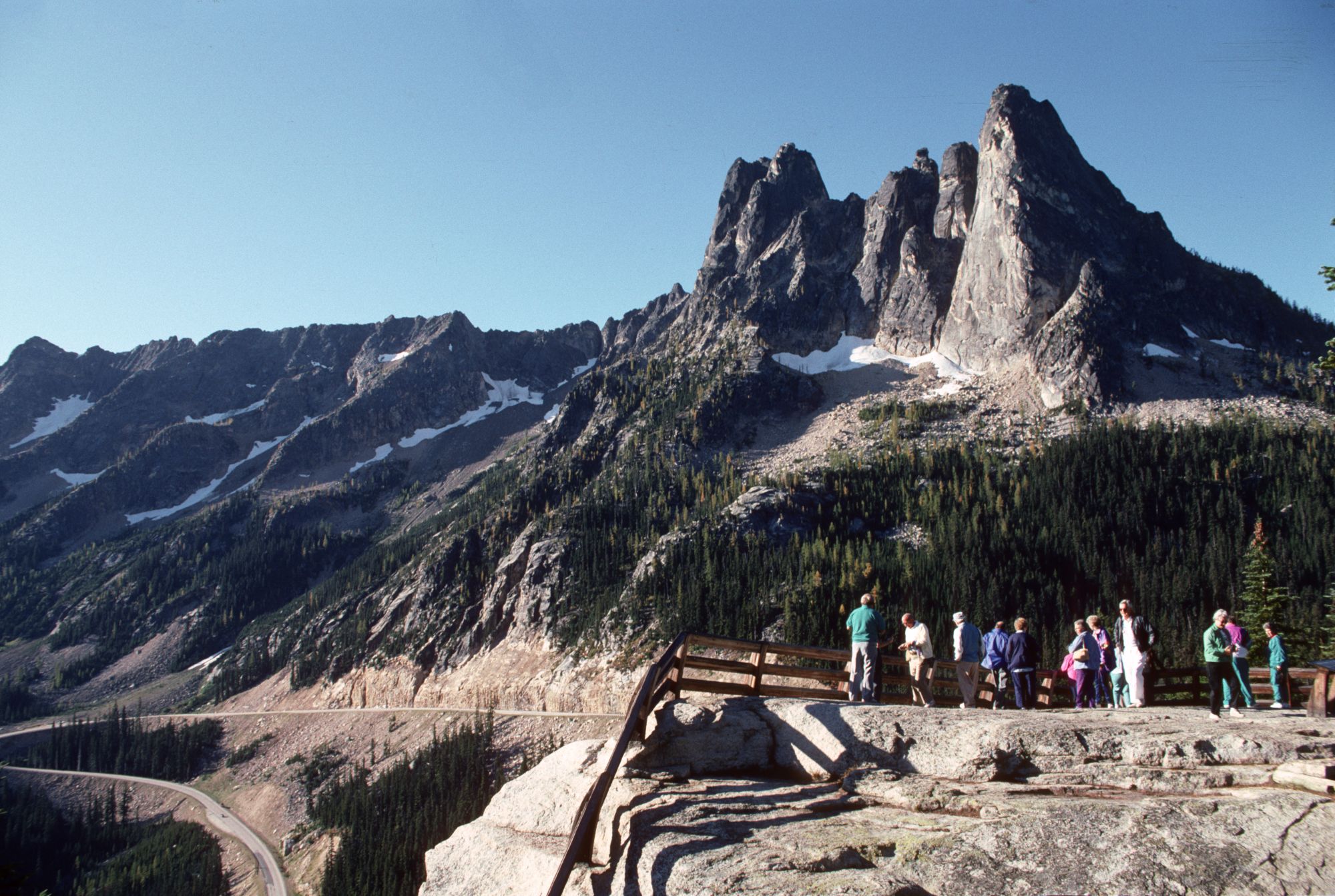
- Trail basics: WTA lists Washington Pass Overlook as 0.25 miles roundtrip with 61 feet of gain and rates it “Easy” (WTA Washington Pass Overlook).
- Tip: This is a “get out, get the view, keep moving” stop. It is ideal for families, mixed mobility groups, and tight itineraries.
- Tip: The overlook is exposed with steep terrain nearby. Keep kids close and avoid letting anyone wander off-trail for photos.
- Tip: In shoulder season, expect icy patches or slick boardwalk/pavement even if the road is technically open. Treat footwear like a safety item, not comfort.
Best views and how to get them fast
- Primary view: Liberty Bell Group and Early Winters Spires. The paved overlook is designed for fast access to the main viewpoint (WTA describes it as a paved trail to a lookout on a ledge) (WTA Washington Pass Overlook).
- Tip: If the main platform is crowded, do not wait in a clump. Walk through, grab photos from the edges, and come back after a few minutes. Turnover is constant on busy days.
- Tip: For photos, aim for morning or late afternoon light. Midday can flatten the rock contrast, especially in hazy conditions.
- Tip: If you are getting blasted by wind at the overlook, step back into the trees along the paved path for a calmer regroup, then return for a short photo window.
Wind and weather tips that matter here
- Expect wind: Washington Pass is a high, exposed saddle and wind is common. Dress for “wind chill,” even on a sunny day (NPS notes the high point at Washington Pass is 5,477 feet) (NPS road conditions).
- Tip: Bring one wind layer per person (even a thin shell). This stop gets miserable fast if you only planned for temperature.
- Tip: If anyone in your group is prone to being cold, do Washington Pass as a “short, decisive stop” rather than a long hangout. Get the view, then move to a lower, calmer stop.
- Tip: In shoulder season, if clouds are dropping, hit Washington Pass first, then do lower-elevation stops on the way back. High points lose visibility first.
Plan A / Plan B and time budgets
- Plan A (SR 20 open and visibility decent): do Washington Pass Overlook as your east-side anchor, then pair it with one easy nearby stop like Rainy Lake if you still have time (check access first) (WTA Rainy Lake) (WSDOT SR 20 status).
- Plan B (closure, weather shift, or wind misery): if SR 20 is not open through the pass, or visibility is collapsing, switch to west-side highlights around Newhalem and the Diablo corridor instead of driving for a closed gate (check official source) (NPS highway highlights) (NPS road conditions).
- Time budget: most groups spend 15 to 30 minutes here (parking, short walk, photos, and back). If you are trying to do it as part of a same-day round trip from the west side, keep it tight or it will steal your daylight.
- Tip: If you are coming from the west side, handle food and fuel before you pass Marblemount so you do not burn time searching for services later.
- Related Guide: Last gas and supplies - fuel and stock up before a long east-side push
FAQ
How long is the Washington Pass Overlook walk?
- WTA lists Washington Pass Overlook as 0.25 miles roundtrip with 61 feet of elevation gain (highest point 5,581 feet) (WTA Washington Pass Overlook).
How do I know if I can reach Washington Pass from the west side?
- Check WSDOT’s SR 20 North Cascades Highway status and NPS road conditions for current closure points (check official source) (WSDOT SR 20 status) (NPS road conditions).
Is Washington Pass Overlook worth it if I only have a short time?
- Yes if you can reach it. It is one of the best “views per minute walked” stops on Highway 20 because the trail is short and paved (WTA description and stats) (WTA Washington Pass Overlook).
Sources
- WTA - Washington Pass Overlook (distance, gain, description)
- WSDOT - SR 20 North Cascades Highway status
- NPS - Road conditions (seasonal closure context, Washington Pass high point)
- NPS - North Cascades Highway highlights
- WTA - Rainy Lake (nearby easy stop when open)
- Wikimedia Commons - Liberty Bell from Washington Pass Overlook (CC BY-SA)
- Wikimedia Commons - Sightseeing at Washington Pass Overlook (Public Domain Mark)
Road status and conditions change quickly in the North Cascades. Before you drive to Washington Pass, confirm SR 20 status and closure points using official sources (WSDOT SR 20 status) (NPS road conditions).

.jpg)