Skip to header Skip to main navigation Skip to main content Skip to footer
Home
Cascades Field Guide
A practical field guide to the North Cascades Highway and surrounding areas.

Main navigation

  • Home
  • This Weekend's Plan
  • Where to Stay
    • Start Here
    • Marblemount
    • Rockport
    • Concrete
    • National Park Campgrounds
    • Winthrop
    • Cabin Rentals vs Campgrounds vs Hotels
  • Trip Planning
    • Start Here
    • One-Day Itinerary
    • Two-Day Itinerary
    • Seasonal Access
    • Camping
    • Food and Services
    • Backup Plans: Rain & Highway Closures
    • Safety and Permits
    • Lakes & Rivers
  • Things To Do
    • Easy Hikes
    • Scenic Stops
    • Family-friendly
    • Dog Friendly Trails
    • Accessible Trails
  • Experiences
    • Fishing
    • River Rafting
    • Self-Guided Tours
    • Wildflowers (spring)
    • Larches (fall)
    • Bald Eagle Viewing (winter)
    • Mushroom Foraging
    • Guided Day Trip from Seattle
  • Areas
    • North Cascades Highway
      • Concrete & Baker Lake
      • Rockport
      • Marblemount
      • Cascade River Road & Cascade Pass
      • Newhalem, Diablo Lake, Ross Lake
      • Rainy Pass & Washington Pass
    • Methow Valley (east side of pass)
      • Mazama
      • Winthrop
  • Get Weekend Updates
  • Area Map

Breadcrumb

  • Home
  • North Cascades Highway

North Cascades Highway: Plan the SR 20 Corridor

Use this page to choose which North Cascades area fits your trip before you start opening individual guides. Some areas work best as overnight bases, some are mainly quick-stop zones, and others are side-road or high-elevation destinations where season, road access, and parking matter more.

If you are planning a Highway 20 trip from west to east, think of this page as the corridor map: Concrete, Rockport, Marblemount, Cascade River Road, Newhalem and the park interior, then Rainy Pass and Washington Pass.

Quick orientation

North Cascades Corridor Map

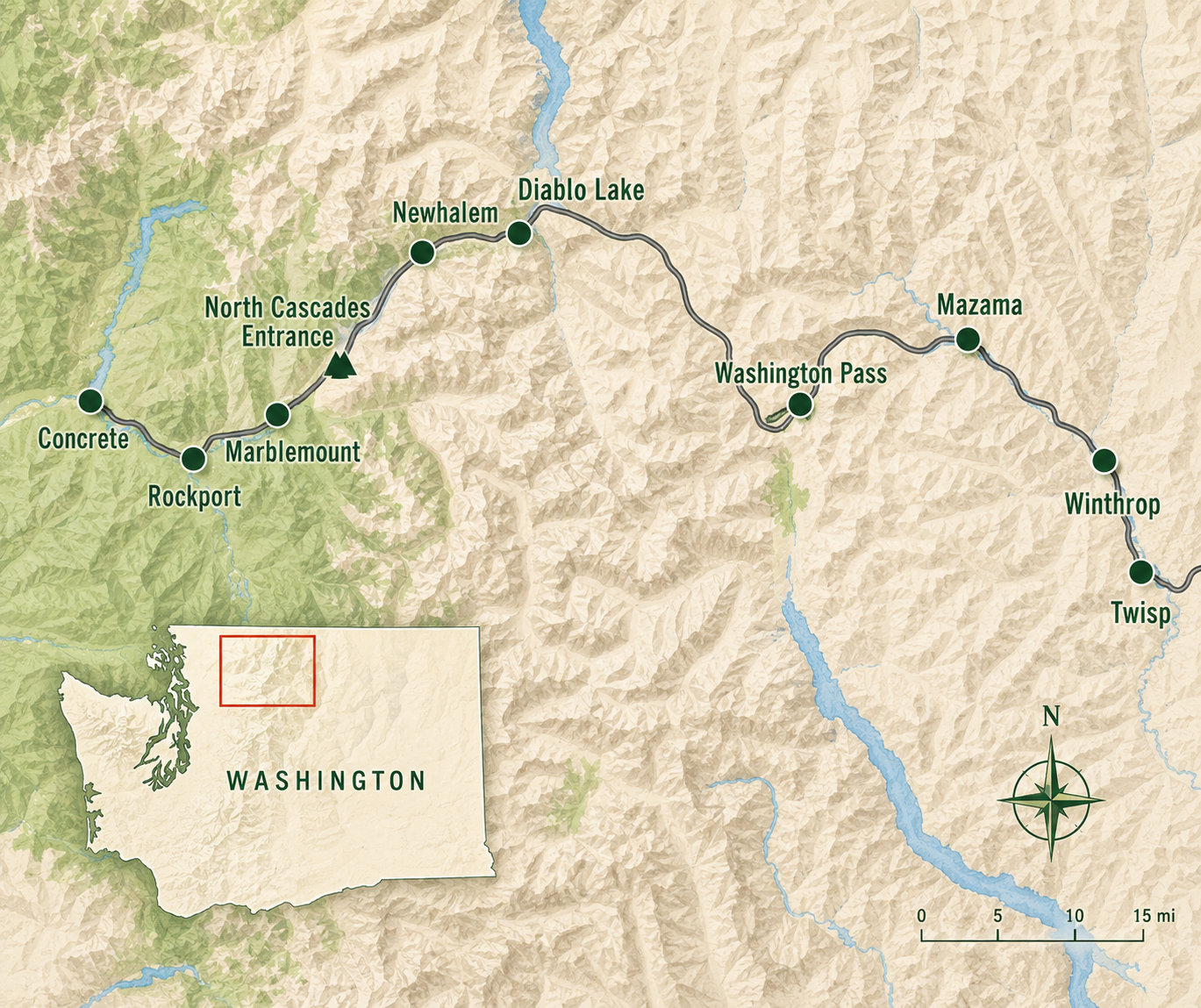
On a good day, Concrete is about a 30-minute drive from the North Cascades National Park entrance area, Rockport is about 20 minutes, and Marblemount is about 7 minutes. Newhalem is just inside the park complex.

The bigger planning split is simple: stay west if you are focusing on Concrete, Rockport, Marblemount, Cascade River Road, Newhalem, Diablo Lake, or Ross Lake. Continue east if your main goal is Rainy Pass, Washington Pass, Blue Lake, Maple Pass, Liberty Bell views, larch season, or Winthrop.

Where to Stay Near North Cascades Compare the best base areas before choosing where to sleep, camp, or stage your trip. Trip Planning Guides Use this hub if you already know the general corridor but need help building the actual plan. 

North Cascades areas, explained

These area pages are not just place names. Each one solves a different planning problem. Use the notes below to decide where to focus first.

Concrete

Best for: visitors who want more services, easier food and fuel access, budget-friendly lodging options, or a west-side base before driving deeper toward the park.

Watch out for: Concrete is farther from the park entrance than Rockport or Marblemount. It can still work well, but it adds drive time if your main goal is an early trailhead start.

Why it matters: Concrete is often the practical choice when you want a real town base instead of staying as close to the park as possible.

Concrete Area Guides Use this area if services, lodging flexibility, and a more developed west-side base matter most. 

Rockport

Best for: quiet stays, Skagit River access, eagle season, nature-focused trips, and visitors who want to be closer to the park than Concrete without staying in Marblemount.

Watch out for: Rockport is smaller and has fewer services. Do not assume late food, fuel, or grocery options will be available.

Why it matters: Rockport is a good middle-ground area if you want quiet access to the corridor without being quite as far west as Concrete.

Rockport Area Guides Use this area for quiet Skagit River access and a less developed base near the park corridor. 

Marblemount

Best for: early starts, last major services before the park, Cascade River Road access, and visitors who want the closest practical west-side base.

Watch out for: Marblemount is convenient, but it is still small. Lodging, food, and services can be limited, especially on busy weekends or late arrivals.

Why it matters: If your trip includes Cascade River Road, Diablo Lake, Newhalem, or a serious hiking day, Marblemount is usually the most useful west-side base.

Marblemount Area Guides Use this area if you want the closest practical base before the park and Cascade River Road. 

Cascade River Road (Marblemount)

Best for: Cascade Pass, Sahale Arm, major hiking days, and visitors who are building a trip around trailhead access instead of casual roadside stops.

Watch out for: Cascade River Road is a side-road decision, not a simple Highway 20 stop. Road conditions, seasonal access, washouts, parking, and early starts can change the plan.

Why it matters: If Cascade River Road is part of your trip, it can determine where you stay, how early you leave, and what backup plan you need if access is limited.

Cascade River Road & Cascade Pass Use this area before committing to Cascade Pass, Sahale Arm, or a side-road hiking day. 

North Cascades National Park Complex and Newhalem

Best for: visitor center stops, easy walks, family-friendly breaks, Newhalem, Gorge Creek Falls, Ladder Creek Falls, Diablo Lake, and Ross Lake access.

Watch out for: The park interior is not the same thing as a full-service town base. Services are limited, and some visitors underestimate how spread out the corridor is.

Why it matters: This is the core park zone for many first-time visitors. It works especially well for scenic stops, short walks, and orientation before continuing farther east or west.

North Cascades Park Complex Guides Use this area for Newhalem, park interior stops, visitor center planning, Diablo Lake, and Ross Lake access. 

Rainy Pass and Washington Pass

Best for: high-elevation scenery, Washington Pass Overlook, Blue Lake, Maple Pass, Lake Ann, Liberty Bell views, larch timing, and visitors continuing east toward Mazama or Winthrop.

Watch out for: This area is more seasonal than the lower west-side corridor. Snow, lingering trail conditions, parking pressure, and Highway 20 access can all matter.

Why it matters: Rainy Pass and Washington Pass are often the scenic payoff of a Highway 20 drive, but they require different planning than Newhalem, Diablo Lake, or Marblemount.

Rainy Pass & Washington Pass Use this area for high-elevation viewpoints, larch hikes, Blue Lake, Maple Pass, and east-side trip planning. 

How to use these area guides

Start with the area that matches your main constraint. If you need lodging or services, compare the town bases first. If you are chasing a specific hike, start with the trailhead area. If you are doing a first-time Highway 20 drive, use the park interior and Washington Pass guides to understand the main scenic zones.

Current Conditions Check road, trail, smoke, snow, and seasonal access issues before committing to an area. Seasonal Access Use this before planning around Highway 20, Cascade River Road, high-elevation trails, or shoulder-season travel. One-Day Highway 20 Itinerary Use this if you want a practical west-to-east stop order instead of choosing one area only. Two-Day North Cascades Itinerary Use this if you need to choose an overnight base and split the corridor into a realistic two-day plan. 

Fishing Near North Cascades and Highway 20: Lakes, Rivers, Species, Rules, and Where to Start

A practical guide to public fishing near Washington’s North Cascades Highway: best lakes for beginners, Baker Lake and Ross Lake logistics, Methow-side options, species by water, licenses, rules, and what to check before you go.
  • Read more about Fishing Near North Cascades and Highway 20: Lakes, Rivers, Species, Rules, and Where to Start

North Cascades Mushroom Season and Legal Foraging Near Highway 20

A practical guide to mushroom season near Washington’s North Cascades Highway: timing by month, common species, legal public-land rules, habitat basics, safety, and trip-planning tips.
  • Read more about North Cascades Mushroom Season and Legal Foraging Near Highway 20

North Cascades Without Hiking: Best Overlooks, Short Walks, Visitor Centers, and Scenic Stops

You can have a good North Cascades day without doing a real hike. The best version is usually a scenic drive built around a few specific stops.
  • Read more about North Cascades Without Hiking: Best Overlooks, Short Walks, Visitor Centers, and Scenic Stops

North Cascades Interactive Map: Highway 20 Stops, Hikes & Services

Use this North Cascades interactive map to find Highway 20 towns, trailheads, scenic stops, services, lodging areas, and trip-planning guides.
  • Read more about North Cascades Interactive Map: Highway 20 Stops, Hikes & Services

North Cascades Highway Seasonal Access Tracker: SR 20 Opening Dates, Closures, and Current Status

Check whether the North Cascades Highway is open, see historic SR 20 opening and closing dates, and understand what partial access means for a North Cascades trip.
  • Read more about North Cascades Highway Seasonal Access Tracker: SR 20 Opening Dates, Closures, and Current Status

What to Book Before a North Cascades Trip: Lodging, Campgrounds, Experiences, Passes, and Backup Plans

Book the right North Cascades lodging, campgrounds, experiences, passes, and backups before driving Highway 20.
  • Read more about What to Book Before a North Cascades Trip: Lodging, Campgrounds, Experiences, Passes, and Backup Plans

When North Cascades Campgrounds Are Full: Where to Stay Instead

North Cascades campgrounds full? Use this backup guide for lodging, cabins, RV parks, towns, and late-arrival trip options.
  • Read more about When North Cascades Campgrounds Are Full: Where to Stay Instead

North Cascades Permits and Safety Guide: Passes, Dogs, Roads, and Trailhead Rules

Know which North Cascades pass, permit, dog rule, and road check applies before you go. Covers SR-20, Cascade River Road, Rainy Pass, Blue Lake, and overnight permits.
  • Read more about North Cascades Permits and Safety Guide: Passes, Dogs, Roads, and Trailhead Rules

Dog-Friendly Trails In and Around the North Cascades

Dog-friendly North Cascades trails along SR-20, with legal options, easy picks by trip length, and help avoiding park-boundary mistakes.
  • Read more about Dog-Friendly Trails In and Around the North Cascades

North Cascades Two-Day Itinerary: Best Route, Overnight Base, and Stop Strategy

North Cascades two-day itinerary with the best route, overnight strategy, and how to split west-side and east-side stops without rushing.
  • Read more about North Cascades Two-Day Itinerary: Best Route, Overnight Base, and Stop Strategy
Pagination
  • Page 1
  • Next page ››

Get Weekly North Cascades Updates

Sign up for the weekly update Trail conditions, seasonal highlights, local insights, and new guides delivered once a week. 
View the guide map

Footer menu

  • Local Business Resources
  • Advertise
  • Support Cascades Field Guide

Lower Footer

  • About Us
  • Privacy Policy
  • Submit a Correction
  • Terms of Service & Disclosures

Copyright © 2026 Cascades Field Guide - All rights reserved