
North Cascades in the Fall: Larches, Smoke, Weather, Road Status, and What’s Still Open
Last updated: May 2026
Fall in the North Cascades is best treated as a high-reward, high-risk SR-20 trip, not a casual shoulder-season drive. The best larch payoff is usually east of Diablo near Rainy Pass and Washington Pass, but smoke, early snow, road status, reduced services, and full trailheads can change the plan fast.
This guide is for visitors planning a one- or two-day trip across the Highway 20 corridor. It helps you decide whether to aim for the high country, stay lower near Newhalem and Diablo, use Marblemount as a launch point, or switch to a backup before wasting the day.
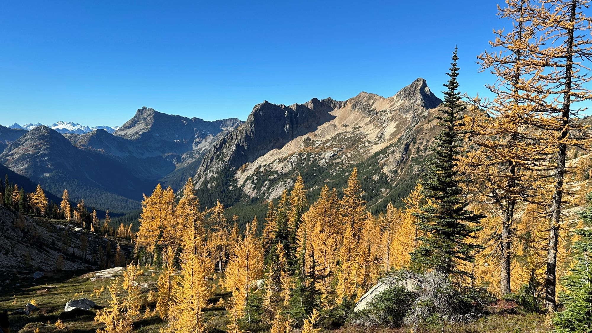
Golden larches near Cutthroat Pass in the North Cascades in fall |CC BY-SA 4.0
Get the North Cascades weekly planning update before a fall trip if road status, smoke, snow, or campground availability could affect your plan.
Quick Decision Guide
- If you want larches: Aim east of Diablo toward Rainy Pass, Washington Pass, Blue Lake, Cutthroat, or the Maple Pass area. Newhalem and Diablo are useful corridor stops, but they are not the main larch zone.
- If you only have a short stop: Use Washington Pass Overlook if SR-20 is open and the pass weather is safe. It gives you the high-country fall payoff without committing to a long hike.
- If weather is poor: Stay lower and west of Washington Pass. Newhalem, Diablo, short waterfall stops, and service stops near Marblemount are safer choices than forcing a pass-level trail.
- If smoke is bad east of the crest: Do not keep driving toward Washington Pass just because Marblemount or Newhalem looked fine. Check smoke before you commit to the long eastbound push.
- If SR-20 is closed or uncertain: Do not plan a through-route. Rebuild the trip around the open side of the corridor or use a west-side backup.
My practical take: A fall North Cascades day should have one main goal and one backup. If your main goal is larches, the backup should not be another high trail at the same elevation. It should be a lower stop, a shorter overlook, or a different area.
How Fall Fits the SR-20 Corridor
Driving west to east on SR-20, the trip changes in stages. Concrete and Rockport are service and approach towns. Marblemount is the last practical west-side launch point before the road feels more remote. Newhalem and Diablo sit inside the park corridor, but they do not solve every fall planning problem.
Why this matters: The best fall color target for many visitors is not the first dramatic stop they reach. The larch-heavy planning zone is farther east, around Rainy Pass and Washington Pass. That means a visitor who stops too long west of Diablo can lose the better weather window, the last legal parking options, or the daylight needed for a high-country hike.
Marblemount beats Newhalem as a prep stop because it has more practical trip services before the park core. Newhalem beats Marblemount only if your plan is focused on visitor-center access, nearby short walks, or camping in the park corridor. Concrete beats Marblemount for more services and lower-cost lodging options, but it puts you farther west from the larch zone.
For an overnight trip, the base choice matters. Stay closer to Marblemount if you want the earliest west-side start toward Rainy Pass or Cascade River Road. Stay closer to Concrete if you care more about services, budget, and flexibility. Use North Cascades Two-Day Itinerary if you need to turn this fall decision into a route plan.
Best Fall Window
September is usually the most forgiving period. Services are more likely to be operating, weather is less winter-like, and SR-20 is less likely to have reached its seasonal closure period. It is also before the narrowest larch rush in the high country.
The larch window usually pulls people east of Diablo toward Rainy Pass, Washington Pass, Blue Lake, Cutthroat, and Maple Pass. Do not treat this as a fixed calendar event. A warm fall, early cold snap, wind, smoke, or new snow can change the result.
Access: Late fall is where the trip gets brittle. Rain is common at lower elevations, snow can affect the mountains, and limited services become a real planning issue. Current road and facility status should be checked before leaving, not from the trailhead parking lot with weak service. Use the Seasonal Access guide before you commit to a late fall plan.
SR-20 has a long history of closing for winter sometime in fall or early winter, but the exact date changes by year. Recent closures have ranged from early November to early December, so a late October or November plan should never assume through access without checking the current road page.
Plan A: Washington Pass Larch Day
Plan A is the high-country fall day. It works best when SR-20 is open, smoke is acceptable, the pass forecast is safe, and you are ready to change plans if parking is full.
- Washington Pass Overlook: Best for a short high-country stop east of Diablo when the road is open and the pass is not icy or wind-blasted. Choose this over a long trail if your group is short on time, tired, or unsure about conditions.
- Rainy Lake: Best for a simpler stop near Rainy Pass when you want an easier outing than Maple Pass. It still depends on access and weather, but it is a more forgiving choice than a full ridge hike.
- Blue Lake area: Best for visitors who want a focused high-country hike near Washington Pass. Treat it as condition-dependent in fall, especially after snow, ice, or heavy rain.
- Maple Pass area: Best for strong hikers who are planning around a larch peak window. Do not make it your only plan. The Rainy Pass lot has limited capacity, and fall demand can overwhelm it.
- Cutthroat area: Best for visitors already committed to the Washington Pass side of the corridor. It can make sense when your goal is high-country fall terrain, but it is not a casual backup from Newhalem or Diablo.
Common mistake: People treat a single trail as the whole fall plan. That is risky. If the lot is full, the trail is snowy, or smoke has settled east of the crest, you need a lower backup before you arrive.
If your day starts west of Marblemount, leave enough margin to make decisions before Newhalem and Diablo. Once you keep driving east, you are committing more of the day to the pass. That is fine when conditions are good. It is a poor bet when the forecast, smoke, or road status is uncertain.
Plan B: Lower Backup Day
Plan B should match the reason Plan A failed. Do not replace a snowy Washington Pass hike with another snowy Washington Pass hike.
- If smoke is worse east of Diablo: Stay west. Use Marblemount, Newhalem, Diablo, short stops, food breaks, and lower-elevation walks instead of driving deeper into the smoke.
- If pass weather is bad: Keep the day below the high trails. Rain near Marblemount can mean snow, wind, or ice around Washington Pass.
- If parking is full: Switch to a short stop, overlook, or lower corridor plan. Do not create an unsafe parking situation along SR-20.
- If SR-20 is closed: Rebuild the trip from the open side. A through-drive plan does not work when the highway is blocked.
- If the group is mixed ability: Use Newhalem, Diablo, Rainy Lake if open, or short waterfall and viewpoint stops. Do not force a full larch hike because one person wants the biggest fall payoff.
This is where people misjudge the corridor: a backup is not just a shorter hike. A good backup changes elevation, road exposure, and service risk. If all your options are east of Diablo and high on the pass, you do not really have a backup.
For lower-effort stops and short walks, use Scenic Stops or Five Easy Hikes Near North Cascades to build a weather-proof day.
What’s Still Open
Fall services shrink as the season moves on. Visitor and information centers close for the season in late September or early October, and the Wilderness Information Center schedule matters if your trip depends on permits or in-person advice.
Services: Do not pass Marblemount without checking fuel, food, restrooms, and basic supplies. Once you are east of Marblemount and moving toward Newhalem, Diablo, Rainy Pass, and Washington Pass, the corridor gives you fewer chances to fix simple planning mistakes. Use Last Gas and Supplies Near North Cascades before you leave the west-side service towns.
Camping also changes after the main season. Some campgrounds may operate differently outside reservation season, and primitive camping can mean no water, no trash service, and fewer support options. If your fall plan includes camping, check the current campground status before you build the trip around it. Use Camping Around North Cascades to compare the main options.
Backcountry camping needs a permit year-round. After the Wilderness Information Center closes, the process changes, and you should not assume you can handle the permit the same way you would in July or August.
For 2026, be extra cautious with road assumptions. SR-20 has had partial closure issues, and the only safe approach is to check both current road status and the pass report before building a through-route.
Side Roads in Fall
Not every side road belongs in a fall SR-20 trip. Some side roads are separate plans, not add-ons.
Cascade River Road: This road leaves SR-20 in Marblemount at mile 106 and serves major trailheads, including Cascade Pass. It can be a strong fall plan only when access is confirmed and your goal is that side of the corridor. It is not a simple fallback for a failed Washington Pass day. Check the road first and use Cascade River Road Access and Trailheads before treating it as part of the same trip.
Baker Lake Road: This can work as a west-side alternative when smoke, weather, or SR-20 access makes the main corridor less useful. The tradeoff is that it changes the whole day. It is better as a backup area than as something to tack onto a Washington Pass larch plan.
Related Guides
Fall conditions in the North Cascades can change quickly. Check current road status, smoke, weather, trail reports, campground status, and permit rules before leaving, especially if your plan depends on Washington Pass, Rainy Pass, Cascade River Road, or a through-drive on SR-20.
