
Cascade Pass and Sahale Arm Guide: Road Access, Parking, Permits, and Backup Plans
Last updated: April 2026
If you do one big hike off SR-20, Cascade Pass (with the potential Sahale Arm add-on) is one of the best choices, but it is also one of the easiest to mess up. The trail itself is only part of the decision. The day can fail because Cascade River Road is not open to the trailhead, parking fills before your group arrives, weather changes the route above the pass, or your overnight permit plan does not match the actual reservation and pickup process.
Use this guide to decide whether you should aim for Cascade Pass only, continue onto Sahale Arm, or plan a permitted overnight at Sahale Glacier Camp. Most visitors should plan Cascade Pass as the main goal and treat Sahale Arm as an optional extension only if road access, parking, weather, snow, and start time all line up.
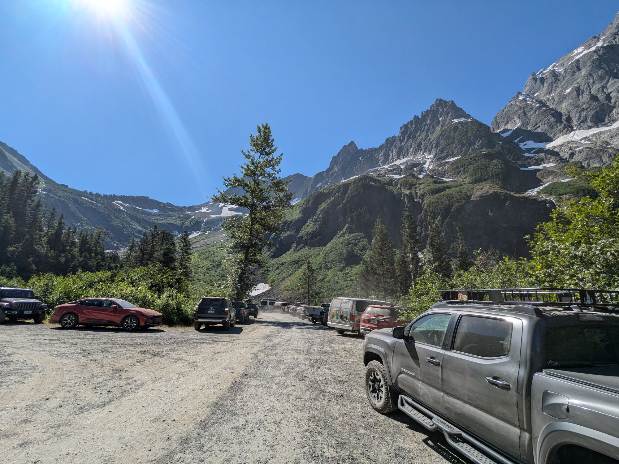
Cascade Pass Trailhead parking lot. Photo: © 2026 CascadesFieldGuide.com. All rights reserved.
Quick Answer
Most visitors should treat Cascade Pass as the main destination and Sahale Arm as the optional extension. If Cascade River Road is open, you start early, parking works, and your group reaches Cascade Pass with plenty of time and energy, continue up Sahale Arm as far as your turnaround time allows.
If you are starting late, hiking with a mixed-ability group, visiting in early season snow, or trying to make a long SR-20 day trip work, stop at Cascade Pass and call it a win.
Cascade Pass and Sahale Arm At a Glance
- Cascade Pass distance: NPS lists Cascade Pass as 3.7 miles one way from the Cascade Pass Trailhead, with about 1,700 feet of elevation gain. WTA lists the round trip as about 7 miles with about 1,800 feet of gain. Check NPS route details and check WTA route details.
- Sahale Arm / Sahale Glacier distance: NPS lists Sahale Glacier as 5.9 miles one way from the trailhead with about 3,940 feet of elevation gain. WTA lists the full Cascade Pass and Sahale Arm route as about 12 miles round trip with about 4,000 feet of gain. Check NPS route details and check WTA route details.
- Difficulty: Cascade Pass is moderate to hard for most casual visitors. Sahale Arm is a hard, committing day hike because the biggest extra effort comes after you have already reached the pass.
- Dogs: Pets are not allowed on this route. Do not plan this as a dog-friendly hike.
- Parking pass / entrance fee: North Cascades National Park does not charge an entrance fee, and WTA lists no parking pass for this trailhead, but always verify official fee guidance and trailhead signs before relying on that. Check NPS fee information.
- Overnight camping: A backcountry permit is required for overnight stays. There is no camping directly at Cascade Pass. Nearby permitted options include Sahale Glacier, Pelton Basin, Basin Creek, and Johannesburg. Check NPS backcountry permit information.
- Main failure point: The hike usually fails before the hiking starts: road access, parking, late start, snow, smoke, or permit logistics.
Should You Hike Cascade Pass, Sahale Arm, or Neither?
Choose Cascade Pass only if:
- You want the most reliable version of the day. Cascade Pass gives you the classic hike without requiring the bigger climb and longer exposure above the pass.
- Your group is mixed ability. This is the better stopping point if some people are strong hikers and others are casual hikers.
- You are starting later than planned. A late start does not automatically ruin Cascade Pass, but it should usually remove Sahale Arm from the plan.
- Weather or smoke is questionable. If visibility is poor, do not turn a good partial hike into a long sufferfest.
Add Sahale Arm if:
- You reach Cascade Pass early. If you are already behind schedule at the pass, Sahale Arm should become optional or off the table.
- Your group still looks strong. The steepest and most committing part of the day comes after the pass.
- You have a hard turnaround time. Decide in advance when you are turning around, even if the views keep improving.
- Snow and weather are within your ability. NPS notes that steep snow sections may require an ice axe for safe travel as late as July. If that is outside your skill set, do not force the upper route.
Skip this hike for the day if:
- Cascade River Road is not open far enough for your plan. A road walk to salvage the route is not what most visitors mean when they choose Cascade Pass.
- You are in a large RV. Cascade River Road has narrow, steep, and sharp sections near the end. It is not a good large-rig road.
- You need a predictable family-friendly stop. This is a serious mountain trail, not a casual roadside viewpoint.
- Your overnight permit is not real yet. Do not build your trip around Sahale Glacier Camp unless the reservation and pickup logistics are actually handled.
Before You Drive: Cascade River Road Access
Cascade Pass is access-sensitive. The first question is not “Can I hike it?” The first question is “Can I reach the trailhead today?” Check official road and trail status before leaving reliable service.
- Road gate reality: If Cascade River Road is not open to the Cascade Pass Trailhead, you are choosing between a long road walk or a different plan. Most visitors should choose a different plan. Check NPS road conditions and check NPS trail conditions.
- Drive-time reality: Cascade River Road leaves SR-20 at Marblemount and runs more than 20 miles to the trailhead. NPS notes that the road is paved for the first portion and then becomes gravel, with narrow and steep sections near the end. Budget more time than the mileage suggests.
- RV warning: Do not take a large RV up this road expecting an easy turnaround. NPS notes that Cascade River Road is not suitable for large RVs because of steep, narrow sections and sharp switchbacks.
- Marblemount reset: Treat Marblemount as your last dependable decision point. Fuel, food, restrooms, permit pickup, and route changes are much easier before you commit to Cascade River Road. Use the Marblemount area guide and services near Marblemount before you drive farther.
Parking Strategy at Cascade Pass Trailhead
Parking is the second major failure point after road access. NPS describes Cascade Pass as the most popular day hike in the national park and notes that it can be busy on summer weekends. That matters because this is not a trailhead where you want to improvise after a late start.
- Start-time rule: If your plan depends on a normal late-morning start, it is fragile. On peak summer weekends, assume you need an early start or a backup plan.
- Full-lot decision: If the lot is full, your real choices are to wait for turnover, park only where clearly legal, or bail to Plan B. Decide this before you reach the end of the road.
- Do not create your own parking: Do not rely on vague shoulder parking or blocking narrow road space. This road has limited room and poor turnaround options in places.
- Carpool problem: If you are coordinating multiple vehicles, make the plan in Marblemount. Cell coverage can be unreliable in this corridor, and “text me when you get there” is not a strong plan.
- Late-arrival rule: If you arrive late and still get a spot, do not automatically keep the full Sahale Arm plan. Recalculate the day from the actual time you start walking.
Cascade Pass vs Sahale Arm vs Overnight
Cascade Pass, Sahale Arm, and Sahale Glacier Camp share the same starting trailhead, but they are not the same trip. The mistake is treating Sahale Arm as an automatic add-on instead of a second decision made at the pass.
Option 1: Cascade Pass day hike
Cascade Pass is the most reliable win. NPS lists it as 3.7 miles one way from the Cascade Pass Trailhead, with about 1,700 feet of elevation gain. It is still a real hike, but it is much easier to timebox than the full Sahale Arm day.
Best for: first-time visitors, mixed-ability groups, people who want a major North Cascades hike without committing to a very long day, and visitors whose timing depends on road access or parking.
Option 2: Sahale Arm day hike
Sahale Arm is the bigger, harder version of the day. WTA lists the route as about 12 miles round trip with about 4,000 feet of gain, and NPS lists Sahale Glacier as 5.9 miles one way from the trailhead. The key planning problem is that the hardest decision happens after you have already done the work to reach Cascade Pass.
Best for: strong hikers, early starts, stable weather, clear air, and groups that can honestly turn around before the top if timing slips.
Option 3: Sahale Glacier Camp overnight
Sahale Glacier Camp is a permit-execution problem first and a hiking problem second. Overnight camping in the North Cascades backcountry requires a permit tied to your itinerary, and permits can be hard to get during busy periods.
Best for: backpackers who already understand the reservation process, can pick up the permit correctly, and are prepared to follow the exact camp/date itinerary on the permit.
Best Season and Common Failure Points
Cascade Pass and Sahale Arm are highly seasonal because both road access and high-elevation trail conditions matter. Do not plan this hike using calendar optimism. Plan it using current road, trail, weather, and smoke information.
- Early season problem: NPS says Cascade River Road typically opens to the Cascade Pass parking lot by the end of June, except in heavy snow years when it may not open until early July. Do not assume late June access without checking official status.
- Snow-travel problem: NPS notes that steep snow sections may require an ice axe for safe travel as late as July. If your group is not prepared for snow travel, keep the plan conservative or choose a different hike.
- Peak summer problem: Road access is usually better, but parking and crowd pressure are worse. Start early and have a backup that still feels worthwhile.
- Smoke problem: Late summer wildfire smoke can quickly reduce the value of a big-view hike. If the AQI is poor, pivot to a lower-commitment day instead of spending all your energy for views you may not get. Check AirNow.
- Fall problem: Fall can be excellent if the road, weather, and trail conditions hold, but days are shorter. Your turnaround time matters more.
- SR-20 problem: If this hike is part of a larger west-to-east North Cascades itinerary, check SR-20 status separately. Highway 20 and Cascade River Road are different access problems. Check WSDOT North Cascades Highway status.
For a broader seasonal planning view, use the North Cascades seasonal access guide and the current conditions page.
Sahale Glacier Camp Permits
Overnight camping in the North Cascades backcountry requires a permit. NPS also notes that there is no camping directly at Cascade Pass, and that Cascade Pass is one of the most popular backcountry destinations in the park, which means permits can be difficult to obtain during busy periods.
- Permit reality: If Sahale Glacier Camp is unavailable, your overnight plan must change. That may mean different dates, a different camp zone, or converting the trip to a day hike.
- Pickup reality: Permit pickup can be a real logistics step, not just a formality. Build your drive, arrival time, and Marblemount stop around the actual permit process. Check NPS permit information and check Recreation.gov permit details.
- Itinerary reality: Your group must follow the itinerary listed on the permit. Do not assume you can casually swap camps after you arrive.
- Camp rules: Fires are not allowed at backcountry camps in this area. Pets are not allowed. Protect fragile vegetation by hiking and resting only on durable surfaces such as trail, snow, or rock.
- Day-hike fallback: If the overnight does not work, Cascade Pass or a partial Sahale Arm day hike can still be a strong trip. Do not let a failed permit plan ruin the whole corridor visit.
Plan A / Plan B: How to Salvage the Day
Plan A: Road open, parking works, conditions are solid
- Before Marblemount: Check Cascade River Road, trail conditions, WSDOT SR-20 status, weather, and smoke.
- In Marblemount: Fuel up, handle food and restroom stops, confirm any permit logistics, and decide your turnaround time.
- At the trailhead: If parking works, start hiking. If parking fails, do not improvise badly. Use your pre-decided fallback.
- At Cascade Pass: Reassess the group, time, weather, smoke, and snow. Continue toward Sahale Arm only if the answer is still clearly yes.
Plan B: Road access, parking, smoke, or timing fails
- Lookout Mountain / Monogram Lake Trail area: Better as a Cascade River Road pivot than driving all the way to a blocked Cascade Pass plan. Check conditions first because this is still a real trail and not a casual replacement.
- Hidden Lake Lookout: A strong alternate only if road access works for your vehicle and conditions are within your ability. Hidden Lake Road / FS 1540 can be rough, steep, narrow, washed out, or snow-affected depending on season.
- Marblemount reset day: If the upper road or weather fails, regroup around Marblemount, Cascade River Road lower-access options, short stops, food, and a different SR-20 plan.
- Highway 20 pivot: If Cascade River Road is the problem but SR-20 is open, shift back to the main corridor and use Newhalem, Diablo Lake, Rainy Pass, or Washington Pass depending on the season and how much day you still have.
For a more complete fallback list, use the Cascade River Road guide and the North Cascades backup plans guide.
FAQ
Do I need an entrance fee for North Cascades National Park?
North Cascades National Park does not charge an entrance fee. WTA lists no parking pass or entry fee for Cascade Pass, but you should still check official fee guidance and trailhead signs before relying on that for your trip. Check NPS fee information.
Are dogs allowed on Cascade Pass or Sahale Arm?
No. Pets are not allowed on this route. Pick a different hike if you are traveling with a dog.
When does Cascade River Road usually open to the Cascade Pass Trailhead?
NPS says the road typically opens to the Cascade Pass parking lot by the end of June, except in heavy snow years when it may not open until early July. That is a pattern, not a guarantee. Always check current NPS road and trail conditions before booking around this hike.
Can I do Sahale Arm without turning the day into a sufferfest?
Yes, but only if you treat Sahale Arm as optional. Reach Cascade Pass early, set a hard turnaround time, and be willing to stop before Sahale Glacier Camp. If the group is already tired at the pass, stop there.
Can I camp at Cascade Pass?
No. NPS says there is no camping directly at Cascade Pass. Nearby permitted camps include Sahale Glacier, Pelton Basin, Basin Creek, and Johannesburg. A backcountry permit is required for overnight stays.
What is the simplest way to avoid wasting the day?
Check Cascade River Road before you leave Marblemount, start early, make Cascade Pass the main goal, and choose your Plan B before you reach the trailhead.
Related Guides
Sources
- North Cascades National Park - Cascade Pass / Sahale Arm Trail
- North Cascades National Park - Road Conditions
- North Cascades National Park - Trail Conditions
- North Cascades National Park - Backcountry Permits
- Recreation.gov - North Cascades Backcountry Permits
- Washington Trails Association - Cascade Pass
- Washington Trails Association - Cascade Pass and Sahale Arm
- WSDOT - North Cascades Highway / SR-20 Pass Conditions
- AirNow - Air Quality and Smoke Information
This is a planning guide, not a live conditions feed. Road access, trail conditions, smoke, weather, and permit logistics can change quickly. For time-sensitive decisions, use the official source links above before you leave Marblemount and before you commit to Cascade River Road.
