Cutthroat Lake or Cutthroat Pass? Routes, Parking, Permits, and Larch Timing
Last updated: July 2026
Cutthroat Lake is the shorter choice for families, casual hikers, and visitors who want a half-day hike near Washington Pass. Cutthroat Pass is a full-day hike with two possible approaches, and most of the climbing comes after the easy lake junction.
This trail system is east of Rainy Pass and Washington Pass on SR-20. It works best when you choose the lake or pass before leaving, start early enough to park legally, and treat the hike as the main event rather than one stop in an overloaded Highway 20 itinerary.
Get North Cascades planning updates for seasonal access, smoke, road conditions, and practical trip ideas.
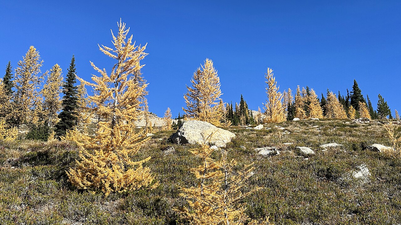
Photo: Golden larches at Cutthroat Pass | CC BY-SA 4.0
Quick Decision Guide
- About half a day: Choose Cutthroat Lake. It is about 3.8 miles round trip with 400 feet of gain and works best for families, casual hikers, and mixed-fitness groups.
- A full day with a lake fallback: Hike toward Cutthroat Pass from the Cutthroat Trailhead. The full route is about 11.4 miles round trip with 2,300 feet of gain.
- A full day focused on the pass: Use the Pacific Crest Trail from the north side of Rainy Pass. This route is about 10 miles round trip with 2,000 feet of gain, but it does not visit Cutthroat Lake.
- Late start or uncertain weather: Stop at Cutthroat Lake. Do not continue toward the pass unless the whole group still has enough daylight, water, and energy.
- Parking is full: Do not park along Forest Road 400 or block the turnaround. Use Washington Pass Overlook only if a designated space is available, or continue east toward Mazama and Winthrop.
Cutthroat Lake
Cutthroat Lake is the easier branch of the same trail system used to reach Cutthroat Pass. It is a complete hike by itself, not merely the place people stop when they fail to reach the pass.
Driving SR-20 west to east, continue past Rainy Pass and Washington Pass toward Mazama. Turn onto Forest Road 400 and follow it for one mile to the Cutthroat Trailhead.
The trail crosses Cutthroat Creek near the beginning and climbs gradually through the lower valley. The main junction is about 1.7 miles from the trailhead.
Turn left at the junction for the final quarter mile to Cutthroat Lake. There is no established trail around the shoreline, so reaching the lake is the natural turnaround point.
Best fit: Choose the lake when your group wants a moderate outing that still feels separate from the roadside stops around the Washington Pass area. It is a better fit than Blue Lake when you want less climbing, but it has its own limited parking and should not be treated as a guaranteed overflow option.
The lake route is reasonable for active children and mixed-fitness groups, but it is not an accessible or stroller-ready walk. Everyone still needs to cover nearly four miles on a natural forest trail.
Common mistake: Do not treat Cutthroat Lake as halfway to Cutthroat Pass. The gentle opening miles come before almost all of the serious climbing.
If someone is already tired when the group reaches the junction, turn toward the lake. The harder part of the pass hike has not started yet.
Choosing a Pass Route
Cutthroat Pass can be reached from the Cutthroat Creek Trail east of Washington Pass or from the Pacific Crest Trail at Rainy Pass. Both routes finish at the same pass, but they solve different planning needs.
Cutthroat Pass via Cutthroat Creek: This route is about 11.4 miles round trip with 2,300 feet of gain. It is the longer option, but it gives you a real decision point before the hardest part of the hike.
The route reaches the lake junction after about 1.7 miles. From there, the pass is another 3.8 miles away and approximately 1,900 feet higher.
This approach is best when the group wants the option to visit Cutthroat Lake or turn the lake into Plan B. Its main disadvantage is that the easy opening can make hikers underestimate what remains.
Cutthroat Pass via the PCT: Driving west to east, the Rainy Pass North Trailhead comes before Washington Pass. This route is about 10 miles round trip with 2,000 feet of gain.
The PCT follows a broad, generally steady grade toward the pass. It is slightly shorter and has less total climbing, but it does not visit Cutthroat Lake.
The north-side PCT parking area is separate from the larger south-side Rainy Pass area used for Rainy Lake, Lake Ann, and Maple Pass. During busy periods, however, the whole Rainy Pass cluster can feel like one parking problem.
Review the Rainy Pass trailhead guide before choosing the PCT approach. That guide explains which hikes share the area and why parking pressure can spread between the lots.
My practical take: Use Cutthroat Creek when hiking ability, weather, or available time is uncertain because the lake remains a worthwhile shorter destination. Use the PCT when everyone is prepared for a full pass hike and the pass is the only goal.
Continue past the junction only when:
- Everyone reached the junction comfortably.
- The group has enough water for a long exposed climb and return.
- The weather is still stable.
- There is enough daylight for another 3.8 miles to the pass and the full hike back.
- No one is assuming the remaining trail will be as gentle as the opening miles.
If any of those answers is no, take the lake branch or return to the trailhead. Cutthroat Pass is not a good place to rescue an overambitious itinerary late in the day.
Parking, Fees, and Rules
Cutthroat parking: The Cutthroat Trailhead is one mile up Forest Road 400 after Washington Pass when driving toward Mazama. The parking area is officially described as very limited and quick to fill.
Follow all posted signs. Leave the roadway, turnaround, and emergency access open. If the lot is full, do not create a parking space along the road.
Rainy Pass parking: The PCT approach begins at the Rainy Pass North Trailhead on the north side of SR-20. This is separate from the main south-side lot, but larch-season demand can affect both areas.
Both starting points have vault toilets but no potable water. Bring all drinking water from your lodging or a service town.
A $5 day-use payment or an accepted recreation pass is required at both trailheads. Accepted options include the Digital Day Pass, Northwest Forest Pass, and Interagency passes such as America the Beautiful.
Download the Recreation.gov app and any needed maps before entering the high corridor. Do not assume that cell service will be available when you need to pay, navigate, or change plans.
No hiking reservation is required: The standard day hikes to Cutthroat Lake or Cutthroat Pass do not require a separate wilderness permit or PCT permit. The PCT Long-distance Permit applies to trips covering at least 500 continuous miles, not a day hike from Rainy Pass.
If you continue north beyond the standard Cutthroat Pass day hike toward Pasayten Wilderness, follow the current trailhead register and wilderness instructions. Overnight camping is prohibited within one-quarter mile of Cutthroat Lake.
Dogs are allowed, but keep them leashed and under control. Review the dog-friendly trail guide before combining Cutthroat with other stops that may use different rules.
Bicycles may use Cutthroat Creek Trail as far as Cutthroat Pass but cannot continue onto the PCT. Bicycles are not allowed on the Rainy Pass PCT approach. E-bikes are prohibited on Cutthroat Creek Trail.
For the wider difference between parking passes, wilderness permits, and national park permits, use the North Cascades permits and safety guide.
Supply planning: Mazama is the closest practical east-side base for an early Cutthroat start. Winthrop is farther away but has a broader range of lodging, food, and services.
Visitors arriving from the west should handle forgotten supplies before committing to the high section of SR-20. Returning to Newhalem or Marblemount after reaching Washington Pass can consume a large part of the hiking day.
Best Season and Larches
Neither trailhead is accessible during the normal winter closure of SR-20. An open highway also does not mean Cutthroat Pass is snow-free.
Early season: Snow can remain on the upper routes after the highway opens. Cutthroat Lake may become practical before the pass, but current trail reports and weather still matter.
Mid-summer: July and August generally offer the most reliable hiking conditions and the main wildflower window. This is also when heat, limited natural water above the junction, and summer parking pressure become important.
Late summer: Trails are more likely to be dry, but smoke can change the trip quickly. Carry enough water from the start rather than planning around uncertain seasonal sources higher on the route.
Larch timing: Cutthroat Pass sits higher than Cutthroat Lake, so the pass can begin changing before the lake basin reaches its strongest color. Historical reports most often place the useful Cutthroat Pass window from late September into the first half of October, with the strongest concentration around early October.
Cutthroat Lake usually develops later. The surrounding slopes may begin turning in late September, while the lake basin often looks better during early to mid-October.
These are planning windows, not guaranteed peak dates. Warm weather can delay color. Wind can remove needles quickly. An early storm can add snow and ice while the larches are still near peak.
Use the North Cascades larch and fall conditions guide to compare recent color reports, smoke, snow, and road risk before choosing a date.
Larch madness: Peak-color weekends change how this corridor works. Rainy Pass, Blue Lake, Washington Pass, and Cutthroat all draw visitors chasing a short seasonal window.
A weekday improves the odds, but it does not guarantee easy parking during peak color. Good-weather weekdays can behave more like summer weekends, especially during the first half of October.
What I would do: Stay in Mazama or Winthrop, prepare the vehicle and day-use pass the night before, and reach the chosen trailhead around first light. I would not start from Seattle expecting to find easy late-morning parking during a peak-color weekend.
Do not treat Cutthroat as a secret backup after Rainy Pass fills. It may be more manageable than Maple Pass or Blue Lake on some days, but its own parking is limited and the trail is well known during larch season.
If you arrive late, use Washington Pass Overlook when legal parking is available. It has faster turnover and is a better salvage stop than repeatedly circling trailheads or parking where you should not.
After roughly October 10: Plan for greater uncertainty. Color may still be good, but burnt-orange needles, needle drop, shaded ice, shorter daylight, and fresh snow become more likely.
Fresh snow during peak larch timing is not unusual. When that happens, downgrade from Cutthroat Pass to Cutthroat Lake or a roadside stop rather than forcing a high route because the trees are gold.
Plan Your Highway 20 Day
Cutthroat Lake can fit into a broader Washington Pass day. Either Cutthroat Pass route should normally be the main event.
Plan A for Cutthroat Lake: Hike to the lake, return to the trailhead, and add Washington Pass Overlook if designated parking is available. Continue east afterward for food or an overnight in Mazama or Winthrop.
This is the better choice for a one-day corridor visitor who still wants time for one or two short stops. It leaves more flexibility than Blue Lake and much more than Maple Pass.
Plan A for Cutthroat Pass: Start early and give the hike most of the day. Choose Cutthroat Creek when you value the lake fallback, or Rainy Pass when you want the shorter PCT approach.
Do not combine Cutthroat Pass with Maple Pass, Blue Lake, or another major hike. That turns one good hiking day into a rushed parking and daylight problem.
Visitors coming from the west should also avoid planning meaningful stops at Newhalem, Diablo Lake, Washington Pass, Cutthroat Pass, and Winthrop on the same day. The drive may look simple on a map, but parking, walking, and turnaround time accumulate quickly.
Plan B for slow progress: If using Cutthroat Creek, make the final decision at the lake junction. Choose the lake when the group is behind schedule, low on water, or already tired.
Plan B for weather: Turn around below the pass when clouds, smoke, snow, ice, or thunderstorms make the upper route a poor choice. If conditions already look bad at the trailhead, do not assume they will improve higher up.
Plan B for full parking: Do not move automatically to Blue Lake or Maple Pass. Those nearby trailheads may be under equal or greater pressure.
Washington Pass Overlook is the best short replacement when a designated space is open. Otherwise continue toward Mazama and Winthrop and use the day for the Methow Valley instead of losing hours to parking roulette.
This is where people misjudge the corridor: A full lot is not a small delay when several nearby lots are also full. The safest decision is often to change the day, not search for a more creative place to leave the vehicle.
Before committing to the high country, check the current SR-20 access and Forest Service alerts listed below.
Sources
- Cutthroat Trailhead — parking, fees, facilities, camping restrictions, and bicycle rules.
- Cutthroat Creek Trail — junction distances, elevation gain, water, and seasonal trail information.
- Rainy Pass North Trailhead — access, fees, facilities, and bicycle restrictions.
- Pacific Crest Trail north of SR-20 — trail access, snow, water, and wilderness instructions.
- PCT permit overview — long-distance permit eligibility.
- Washington mountain passes — current SR-20 access and travel conditions.
- Forest Service alerts — current closures, restrictions, and emergency notices.
Related Guides
Road access, parking rules, fees, fire closures, weather, snow, and permit instructions can change. Check current WSDOT and Forest Service information before traveling, and follow all posted trailhead signs.