
North Cascades Highway Seasonal Access Tracker: Is SR 20 Open in 2026?
Last updated: May 2026
Use this page to check the practical seasonal-access picture for the North Cascades Highway, also called SR-20. The important question is not just whether the highway is “open.” The useful question is whether it is open as a full west-to-east route across Rainy Pass and Washington Pass, or only partly accessible from one side.
For 2026: SR-20 has had repair-related closures and is expected to fully open by June 25. Check official WSDOT and park road sources before committing to a Seattle-to-Winthrop drive, Washington Pass hike, or full Highway 20 day trip.
Get weekly North Cascades trip updates before you commit to a spring, early summer, or fall Highway 20 plan.
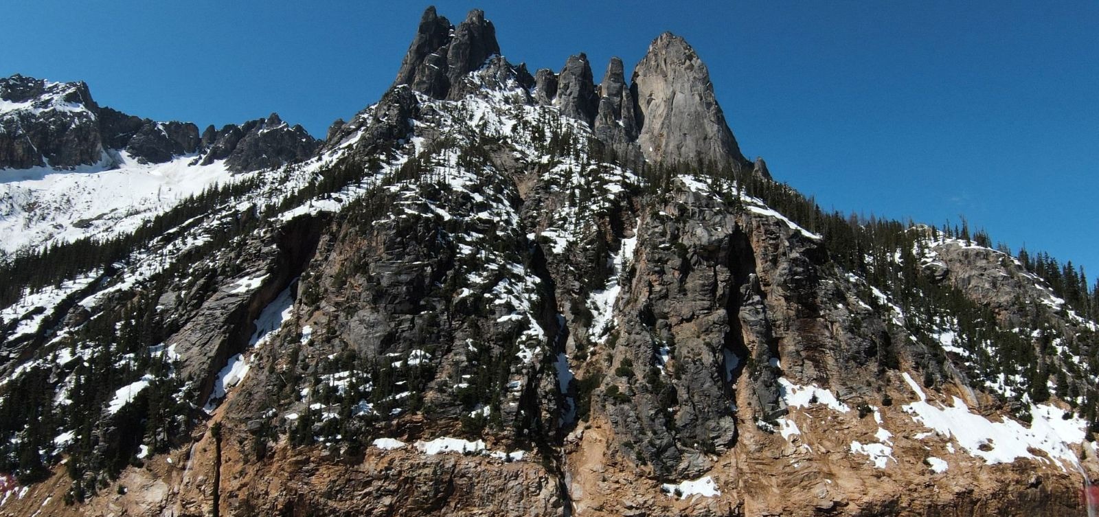
Liberty Mountain from Washington Pass / Photo: © 2026 CascadesFieldGuide.com. All rights reserved.
Quick Decision Guide
In a normal year, North Cascades Highway usually opens sometime in April or May. WSDOT’s historical opening table shows recent North Cascades SR-20 openings between April 18 and May 12 from 2019 through 2025, with older years showing wider swings. Check the WSDOT opening and closure history for the full official table.
For 2026: treat the highway as a repair-affected route until the full opening is confirmed. Partial access may still allow a west-side trip, but it does not create a full cross-Cascades route.
- If you only want Newhalem or Diablo: A west-side trip may still work when the pass is closed farther east, but check the exact closure point first.
- If you want Washington Pass: You need SR-20 open east of Diablo and across the high pass. A partial opening is not enough.
- If you want Winthrop from Seattle: Confirm full through-access before booking east-side lodging.
- If you want Maple Pass or Blue Lake: Road access is only the first question. Snow can remain on high trails after the highway opens.
- If the road is closed: Use a west-side plan around Marblemount, Newhalem, Diablo if reachable, or a separate backup area.
For today’s broader trip call, start with current North Cascades conditions.
What “Open” Actually Means
“Open” can mean different things depending on where you are starting and what you are trying to do. This is why the exact closure point matters more than a general headline.
- Open to Newhalem: Good for west-side stops, short walks, visitor-center-style planning, and some low-elevation options. Not enough for Washington Pass or Winthrop from Seattle.
- Open to Diablo: Good for Diablo Lake views and some short stops if the road and parking areas are available. Still not a full Highway 20 crossing.
- Open across Washington Pass: This is the full west-to-east route most visitors mean when they ask whether the North Cascades Highway is open.
- Partially open from the east: Useful for Mazama, Winthrop, and east-side access, but it does not help a west-side visitor cross from Seattle, Skagit County, or Marblemount.
Before using “open” as a trip decision, check whether the road works for your actual route: west side only, east side only, or full through-drive.
Recent SR-20 Opening and Closing History
Recent history is useful because it shows the normal planning window, but it should not be treated as a promise. Snowpack, avalanche work, rockfall, washouts, culverts, road damage, and emergency repairs can all change the opening date.
- 2025: Opened April 22 and closed Dec. 4. Typical spring opening, later closure.
- 2024: Opened April 19 and closed Nov. 18. Good example of an April opening.
- 2023: Opened May 11 and closed Nov. 30. May opening; do not assume April every year.
- 2022: Opened May 10 and closed Nov. 3. Later spring opening and earlier fall closure.
- 2021: Opened May 5 and closed Nov. 15. Typical May-opening planning pattern.
- 2020: Opened May 12 and closed Nov. 16. Another May-opening year.
- 2019: Opened April 18 and closed Dec. 11. Recent early-opening example.
The recent pattern supports a simple planning rule: April can work in some years, May is common, and June is usually safer for visitors who need more certainty. For high trails, the road opening is not the same as summer trail conditions.
Seasonal Access Calendar
This is the practical planning pattern for most visitors. It is not a guarantee for any specific year.
- March: Usually too early for a full North Cascades Highway crossing. Plan west-side access only unless official sources say otherwise.
- April: Possible opening month in some years, but too uncertain for a must-work cross-state itinerary.
- May: Common opening window, but early May can still be uncertain and high trails may remain snowy.
- June: Better for through-drive planning, but early June can still be too soon for some high-elevation hikes.
- July through September: Strongest general window for full Highway 20 trips, Washington Pass stops, and higher trailheads.
- October: Often still possible, but weather shifts faster and early snow can affect high areas.
- November: Closure risk rises. Do not build a fragile itinerary around a late-season crossing.
- December through February: Treat the high pass as a winter closure area and use west-side or alternate-region plans.
For a broader month-by-month trip decision, use the Best Time to Visit North Cascades guide.
Why Opening Changes
North Cascades Highway crosses high avalanche terrain between the west side of the park and the Methow Valley. The road is not just waiting for snow to melt. Crews must clear snow, check avalanche paths, remove debris, and repair damage before the road can safely work as a public route.
Common mistake: Do not assume a warm spring in Seattle means the highway is ready. Washington Pass is much higher and holds winter conditions longer than the towns west of the park.
Some years are simple snow-clearing years. Other years involve rockfall, washouts, damaged road shoulders, culverts, or emergency repairs. That is why the opening date can move from early April in one year to May or later in another year.
For a visitor driving east on SR-20, the important breakpoints are Marblemount, Newhalem, Diablo, Rainy Pass, Washington Pass, Mazama, and Winthrop. A closure east of Diablo can still allow a west-side day trip, but it can cancel the cross-mountain part of the plan.
What Opening Does Not Mean
Opening the highway does not mean every trail, side road, campground, or viewpoint is fully ready. It means the road has reached a level where traffic can use the route under the current rules.
This is where people misjudge the corridor: A road can be open while nearby trails are still very snowy. Rainy Pass, Washington Pass, Maple Pass, Blue Lake, and other high trailheads can lag behind the road opening by weeks. The best general weather window is usually mid-June through late September, and higher trails may still hold snow before then. Check the park weather guide before treating early season as summer.
Campgrounds, side roads, and trailheads may follow their own timelines. A full SR-20 opening does not automatically mean Cascade River Road, Thornton Lakes Road, Hidden Lake Road, Harts Pass Road, or high-elevation trailheads are ready.
Before you pass Marblemount, think about fuel, food, restrooms, and turnaround options. If the highway status changes, west-side services matter more than usual. Use the last gas and supplies before the pass guide if you are not sure where to stop.
Plan A / Plan B
Plan A: full SR-20 through-drive. Use this plan only when the highway is open all the way across. From the west, drive through Marblemount, Newhalem, Diablo, Rainy Pass, Washington Pass, and then toward Mazama or Winthrop. This is the right plan if your goal is a classic Highway 20 day, Washington Pass, or an east-side overnight.
For a simple route shape after the road is fully open, use the North Cascades Highway One-Day Itinerary.
Plan B: west-side-only trip. Use this plan when the pass is closed or only partly open. Keep your day west of the closure. Marblemount works better than Winthrop for this plan because it keeps you near services, Newhalem, and west-side alternatives. Winthrop can still be useful from the east side, but it does not solve a closed west-to-east crossing.
Plan C: postpone the pass-focused trip. If your main goal is Washington Pass, Blue Lake, Maple Pass, or a full Seattle-to-Winthrop drive, a partial opening is usually not worth forcing. Save that plan for a confirmed open-road window.
What I would do: If the closure blocks Washington Pass, I would not force a pass-focused trip. I would switch to a shorter west-side plan, check whether Diablo is reachable, and save Washington Pass for a confirmed open-road window.
What to Check Before You Leave
- WSDOT pass report: Use the North Cascades Highway pass report for the current highway status.
- WSDOT opening and closure history: Use the historic opening and closing dates for seasonal context.
- Park road conditions: Check NPS road conditions for park-managed roads and related access notes.
- Cascade River Road: If your backup plan involves Cascade Pass, check Cascade River Road separately.
- Weather: Check the park weather guide and a current forecast before treating the pass as a summer drive.
- Food, fuel, and turnaround options: Use the last gas and supplies guide before you commit to driving deeper into the corridor.
Related Guides
This guide is for planning, not live road control. Before leaving, check official WSDOT and park road updates, then build your route around the exact closure point, not a general statement that the highway is open or closed.
