
Bacon Creek Road / NF-1060 Guide: What’s There, What’s Not, and Access Reality
Last updated: June 2026
Bacon Creek Road / NF-1060 turns off SR-20 east of Marblemount, before Newhalem, Diablo Lake, and the main North Cascades Highway stops. Use it only if you have a high clearance vehicle and want rough-road scouting or dispersed camping options; skip it if you want a predictable hike, restroom, signed campground, or scenic stops.
As of June 2026, the road was fully accessible for high clearance vehicles all the way to the end (the bridge crossing Bacon Creek).
Get the weekly North Cascades planning email before you drive SR-20 for current road, weather, smoke, and access notes.
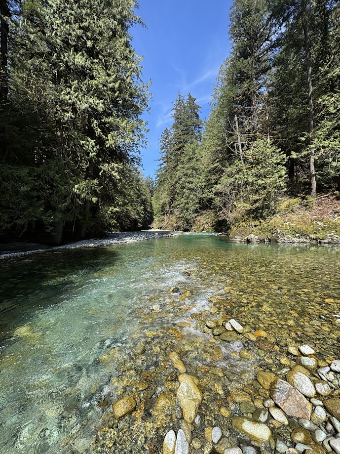
A meltwater wading pool in Bacon Creek. Photo: © 2026 CascadesFieldGuide.com. All rights reserved.
Quick Decision Guide
- Use Bacon Creek Road if you are already near Marblemount and your goal is rough-road scouting or dispersed-camping options.
- Skip it if this is your first North Cascades trip and you want a clear payoff. Cascade River Road or the main SR-20 corridor will usually give you a better use of limited time.
- Do not treat Bacon Creek as a destination. Use Marblemount for services, then continue east toward Newhalem or a signed stop.
- With a half-day and a high clearance vehicle, you can scout the road, but set a hard turnaround point if the road feels worse than your plan.
- In heavy rain, smoke, or pass-closure uncertainty, Bacon Creek can be a nearby low-elevation option for outdoor exploration, but it is not a replacement for Washington Pass, Diablo Lake, or a real trailhead day.
Map
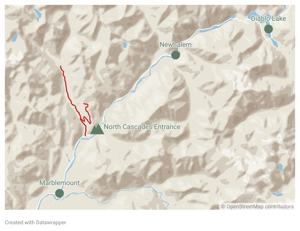
Where It Fits on SR-20
Bacon Creek Road is a north-side forest road east of Marblemount. If you are driving SR-20 west to east, you reach Marblemount first, then the Bacon Creek turnoff, then Newhalem, Diablo, and the higher highway corridor.
That location is the main reason people notice it on a map. It looks like an easy side road before the park corridor gets more committed. The problem is that the road does not act like a visitor stop.
Use case: Bacon Creek is best for self-sufficient visitors who already understand forest-road tradeoffs. It can beat Cascade River Road for a short local scout because it is closer to SR-20 and easier to abandon. Cascade River Road beats it for road quality, actual trailhead value, named hikes, and a clearer day plan.
If your real goal is a classic North Cascades hike, start with the Cascade River Road Access Guide instead. If your goal is a quick stop after Marblemount, keep moving east toward Newhalem rather than turning onto an uncertain side road.
What’s Actually There
Bacon Creek Road is a national forest road with informal use, rough sections, pullouts, and access toward Bacon Creek drainage. It is not built around visitor facilities.
Camping: Decades ago, Bacon Creek had its own national forest campground. Unfortunately, it washed out too many times and was abandoned. Nowadays there are no guaranteed sites, no campground host, no picnic loop, no toilet, and no water system to rely on. Disbursed camping is allowed, however, and many sites exist, if your vehicle can reach them.
If you are looking for dispersed camping, bring your own toilet plan, water, trash bags, and food storage. The mistake is assuming “forest road” means “easy camping.” On Bacon Creek, the first usable-looking pullout may be the only one that fits your vehicle and comfort level that day.
Don't pass Marblemount without solving for fuel, food, and restrooms. Use the Services Near Marblemount guide before you leave the highway for a rough side road.
Lazy Bear Falls is the named objective people most often connect with this road, but it should not be treated as a casual family hike. Trail references describe access tied to a washout area and very limited parking. That makes it a niche objective, not a reliable recommendation for a visitor with one North Cascades day.
What’s Not There
Do not turn onto Bacon Creek Road expecting a developed recreation site. The road does not give you the basic certainty that most visitors need on a short SR-20 trip.
- No signed campground loop to compare with Newhalem, Colonial Creek, or other developed campgrounds.
- No reliable restroom stop after leaving SR-20.
- No visitor center, ranger desk, or staffed checkpoint.
- No guaranteed turnaround if you keep pushing beyond your vehicle’s comfort level.
- No dependable overflow plan if every usable pullout is occupied.
The easy hikes near Marblemount and Newhalem are a better fit because they are built around clearer parking and shorter visitor decisions.
Access Reality: Plan A / Plan B
Bacon Creek access can change quickly after storms, washouts, downed trees, snow, or creek damage. Forest-road reports can also age badly. A road that worked for one visitor in one season may not match what you find on another trip.
Plan A: If the road is open enough for your vehicle, treat the first part as a scouting drive, not a commitment. Download maps before Marblemount and turn around before the road condition becomes the main event.
Plan B: If the road feels rough, pullouts are full, rain is active, or you are unsure about turning around, turn around and use the rest of your day on SR-20. For a hiking day, switch to Cascade River Road if that road and parking situation fit your plan. For a low-stress visitor day, continue east to Newhalem and the signed Highway 20 stops.
If SR-20 is closed farther east for the season, Bacon Creek should still be reachable from the west side. That does not make it a replacement for Washington Pass, Rainy Pass, or east-side trailheads. Check the Seasonal Access Guide before building a pass-crossing plan around any side road.
Better Nearby Options
Choose the alternative based on the problem you are trying to solve.
- Cascade River Road: Better for a real hiking objective near Marblemount. The tradeoff is more parking pressure, more commitment, and seasonal road issues.
- Marblemount: Better for fuel, food, bathrooms, and resetting your plan before you continue east. The tradeoff is that it is a service stop, not the main outdoor destination.
- Newhalem: Better for first-time visitors who want a simple SR-20 stop after Marblemount. The tradeoff is that it does not solve dispersed camping.
- Baker Lake Road: Better if your whole trip is shifting toward a west-side forest-road and lake plan. The tradeoff is that it changes the day shape and pulls you away from the main North Cascades Highway flow.
- Washington Pass: Better for high-country viewpoints and east-side access when SR-20 is open. The tradeoff is distance, seasonality, and no help if the pass is closed.
The practical rule is simple: use Bacon Creek when you specifically want Bacon Creek’s rough-road, informal-use reality. Do not use it just because it appears close to Marblemount on the map.
Sources
- Mt. Baker-Snoqualmie Current Conditions - road, trail, alert, and fire-status checks.
- MBSNF Road and Trail Conditions Map - forest road and trail condition reference.
- Camping Restrictions - dispersed-camping time limits on national forest land.
- Food Storage Order - bear-resistant food and attractant storage rules.
- WSDOT North Cascades Highway - current SR-20 pass status.
- WTA Lazy Bear Falls - trail access and parking reference.
Related Guides
Forest roads, fire rules, food-storage rules, and SR-20 conditions can change quickly after storms, snow, smoke, or road damage. Check official sources before you go, and do not continue on Bacon Creek Road if the road condition, turnaround space, or your vehicle changes the risk of your day.
